
Report: travel-time data lacking at key spots on Portland-area freeways
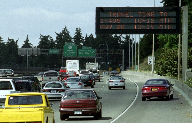
It’s a common occurrence: a digital signboard over the freeway tells you to expect a 15-minute trip, but traffic clears and you arrive in 10 minutes. Or, worse, you hit a clog and arrive in 30 minutes.
Sometimes those signboards, called dynamic message signs, are way off, Portland State University researcher Kristin Tufte found. But sometimes that doesn’t matter.
Tufte examined the signboards, called dynamic message signs, along Portland-area freeways in an OTREC project. Drivers typically reach their destinations earlier or later than the signs told them to expect when a so-called “shock wave” forms or dissipates; that is, when traffic suddenly bunches or clears up.
Currently, only three of the 30 or so message signs in the Portland metro area display travel times. Detectors at freeway onramps feed those signs. As a result, large swaths of freeway without onramps also have no data. To be most useful, new message signs would require more detectors in certain areas.
Take the busy Marquam Bridge in Portland, where busy freeways merge and there is no signboard. “There’s no detection for the whole length of the bridge,” Tufte said. “If you really want to have accurate travel times, you have to have detection there.”
As expected, Tufte found that traffic bunching or clearing in blind zones can throw off the accuracy of travel times displayed. Surprisingly, that inaccurate information is often good enough. Tufte summarizes the findings in a new report.
Because travel time on stretches of freeway such as Interstate 5 northbound vary so much from day to day, even ballpark numbers can be useful. “If one day (the trip) is 10 minutes and the next it’s 30 minutes, if I get you an estimate that’s within 2 minutes, that’s probably going to be helpful,” Tufte said.
On Interstate 5 southbound, however, the travel times are more predictable. If a typical trip varies only a few minutes from day to day, an estimate that’s 2 minutes off won’t provide any useful information.
Placing the signs closer together can reduce inaccuracy but not eliminate it entirely, said Dennis Mitchell, Region I traffic engineer with the Oregon Department of Transportation. “As soon as you put a message on a sign, that data’s old,” Mitchell said. “If it’s 10 miles, 10 minutes, to downtown, things can change.”
The research caused Tufte and co-investigator Soyoung Ahn of the University of Arizona to step back and look at what drivers use the signboards for. “Another way to look at accuracy is how people are using it,” Tufte said.
“Maybe all you have to do is choose between two routes, a freeway and an arterial,” she said. “As long as you get the rankings OK, you’re getting some benefit.”
This research has helped ODOT focused on improving accuracy where it most helps drivers. “We found out, based on some of the work that Kristin did, that we have gaps,” Mitchell said. “We don’t have sensors where we need to.”
Given limited resources, officials are installing detectors where they’ll provide the most useful information, rather than treating all accuracy improvements the same whether they’re on predictable or unpredictable stretches of freeway.
The approach makes sense, Tufte said. “If I-5 north is causing the pain, you should focus your attention on I-5 north.”
Learn more about the project or download the report.