

An OTREC report from Oregon State University looked at various center median and bicycle lane configurations, and how they affect traffic at road access points.
In the American Association of State Highway and Transportation Officials (AASHTO) publication A Policy on Geometric Design of Highways and Streets, commonly known as the Green Book, access points include the intersections of public roads as well as driveway locations. In the Green Book, most of the supporting research for the spacing of driveways is based on standard highway design procedures. They include simple human factors and geometric principles, and have not been thoroughly evaluated based on a variety of road cross section configurations.
Principal investigator Karen Dixon of Oregon State University sought to close this research gap by evaluating the influences of select cross-sectional-related design elements, specifically median configurations and bicycle lanes, on driveways.
Dixon's research team evaluated eight physical sites and four simulated scenarios with different driveway spacing and roadway cross section designs. The primary...
Read more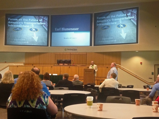
Congressman Earl Blumenauer called together a group of transportation policy makers on Monday, August 4, for a “Rebuilding and Renewing” forum.
Transportation professionals and officials from every level of government, from the federal to the local, met at Portland State University to discuss how to maintain and revive America’s transportation infrastructure.
Blumenauer, the representative for Oregon’s 3rd Congressional District, advocates fuel taxes and VMT taxes to pay for infrastructure needs.
As the Highway Trust Fund rapidly shrinks and America’s deteriorating roads and bridges silently cry out for maintenance, Congress is in the process of trying to determine the best, most sustainable path forward.
During Monday’s forum, a variety of voices were sought out and listened to. Bill Wyatt, executive director of the Port of Portland, gave opening remarks and introduced Blumenauer, who spoke about dwindling highway funds and the need for investment in infrastructure to keep the nation’s economy alive.
He was followed by Tamara Lundgren, CEO of Schnitzer Steel and Chair of the U.S. Chamber of Commerce, who described infrastructure maintenance as both an...
Read more
Transit supporters offer up a host of arguments for their favorite form of transportation but may struggle to counter a response of “prove it.” This year’s Oregon Transportation Summit could help change that.
Fresh research showing some of the benefits of transit will keep the public transportation track lively and relevant during the sixth annual summit. Morning and afternoon workshops spotlight transit, bookending a luncheon keynote by noted transit planner Jarrett Walker.
The Oregon Transportation Summit takes place Monday, Sept. 15 at Portland State University.
University of Utah researcher Reid Ewing made national and international headlines recently with a study showing the effect of light rail in a busy travel corridor. The study, funded by the National Institute for Transportation and Communities, was the first to...
Read more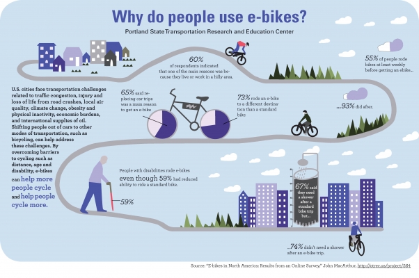
As part of an ongoing project studying the use of electric-assist bicycles, or e-bikes, a research team led by TREC's John MacArthur conducted an online survey of e-bike users on their purchase and use decisions. The results, highlighted in this infographic, suggest that e-bikes enable people to bike more often, bike farther and carry more cargo than on a traditional bicycle. In addition, e-bikes let people ride a bike who otherwise could not because of physical limitations or distance.
Click image for larger version: Please include attribution to trec.pdx.edu
Share this Image On Your Site
Read more
Three Portland State University graduate students in the Nohad A. Toulan School of Urban Studies and Planning used GIS technology to collect and analyze residents’ thoughts about walkability needs for Portland, Oregon’s northeast Cully neighborhood.
In PPGIS, community input is used to create GIS-based data and diagnostics maps which can inform planners’ decision-making process. Team members Travis Driessen, Brandi Campbell and Eduardo Montejo worked with community-based organizations and residents to assess the needs of the Cully neighborhood’s pedestrian network using PPGIS methods.
Prior to this project, Driessen, who is working toward a graduate certificate in Geographic Information Systems at PSU, was already collaborating with David Hampsten, a board member of the Hazelwood Neighborhood Association and member of the East Portland Action Plan, to help Prioritize Portland! – a coalition consisting of multiple organizations including the ...
Read more
New research from NITC looks at Health Impact Assessment, or HIA, in transportation planning.
The leading causes of death in the United States are no longer communicable diseases. Instead, chronic conditions linked to behaviors and shaped by environments—such as obesity and diabetes—are today’s most pressing public health concerns.
HIA is a way of evaluating the effects that planning decisions will have on public health.
Researcher Nicole Iroz-Elardo studied this relatively new endeavor, analyzing and comparing three contemporary case studies in HIA.
She will share her findings in an IBPI webinar on July 16, 2014.
By engaging professionals from multiple disciplines, HIA can give planners a larger knowledge base to inform decisions.
In a collaborative process that did not emerge in the U.S. until 1999, stakeholders and community members engage with public health professionals to identify and deliberate about health interests related to the proposed plan.
They generally focus on health equity, and use as a framework the social determinants of health: a broad...
Read more- An analysis of the effects of commuter rail on population deconcentration.
- A look into prioritizing pedestrians at signalized intersections.
- A study of cyclist-vehicle interaction.
- An evaluation of an eco-driving intervention.

What is the highest number of deaths and serious injuries we should accept from our transportation system? For transportation agencies who have long sought to reduce traffic fatalities, a movement to eliminate them completely has gained currency.
This year’s Oregon Transportation Summit brings a strong safety theme, including plenary session and morning and afternoon workshops. Registration for the summit officially opens today.
Register or learn more about the summit, which takes place Monday, Sept. 15.
The 2014 Oregon Transportation Summit opens with a plenary session titled “Envisioning Vision Zero.” Vision Zero is the approach, initiated in Sweden, to not accept deaths or serious injuries as a tradeoff for other goals of the road network. In the United States, a national effort called Toward Zero Deaths grew out of these principles.
Minnesota Toward Zero Deaths has been a leader among state programs, working with partners across jurisdictions and service categories across the state to address roadway deaths and injuries. Sue Groth oversees this effort as the state traffic engineer and director of the Office of Traffic, Safety and Technology for the...
Read more
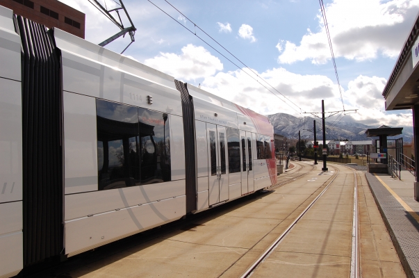
For the first time, researchers have shown that installing light rail on an existing travel corridor not only gets people out of their cars, but reduces congestion and air pollution.
In the study, planners at the University of Utah measured impacts of a new light rail line in Salt Lake City (University Line) on an existing major thoroughfare (400/500 South). Their analysis showed that traffic near the University has fallen to levels not seen since the 1980s, even as the number of students, faculty and staff at the university has increased, and the commercial district along the corridor has expanded.
"This is the first study to document important effects of light rail transit on traffic volumes,” said Reid Ewing, professor of city and metropolitan planning at the University of Utah and lead author on the study. “Since the University TRAX line opened, there has been increased development in the 400/500 South travel corridor, yet traffic on the street has actually declined. Our calculations show that without the University TRAX line, there would be at least 7,300 more cars per day on 400/500 South, and possibly as many as 21,700 additional cars. The line avoids gridlock, as well as saves an additional 13 tons of toxic air pollutants. This is important knowledge for shaping future transportation policies.”
Andrew Gruber, executive director of the...
Read more