NITC Webinar: Arterial Reliability Performance Metrics w Jason Anderson of Portland State

PRESENTATION ARCHIVE

Miss the webinar or want a look back?

OVERVIEW

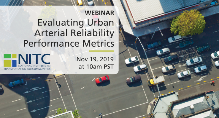
With worsening congestion, travel time reliability is increasingly becoming as critical as average travel times in affecting travel choices. Researchers from Portland State University (PSU) partnered with Washington County, Oregon to offer data-driven strategies in prioritizing funding for travel time reliability improvements on their urban arterials. The vast majority of existing research on travel time reliability has focused exclusively on freeways. Avinash Unnikrishnan, Sirisha Kothuri and Jason C. Anderson leveraged Bluetooth sensors provided and deployed by Bluemac Analytics to identify problem areas in the county. Set up at intersections throughout Washington County, the sensors are able to calculate travel time from one intersection to another by matching Bluetooth signals from devices in people's cars. The researchers evaluated the Bluetooth travel time data to understand the temporal variation in travel time reliability metrics on these urban arterials, including factors related to time of day, weather, and holidays....

Read more

The video begins at 1:47.

Joseph Broach, PhD candidate in Urban Studies, will discuss the results of his research, which models the propensity of children aged 6-16 to walk or bike to parks and school without an adult chaperone, extending existing work on children’s active travel in several ways: 1) focus on travel without an adult, 2) inclusion of school and a non-school destinations, 3) separate walk and bike models, 4) consideration of both parent and child attitudes and perceived social norms, 5) explicit inclusion of household rules limiting walking or bicycling.

The proliferation of information technology in the transportation field has opened up opportunities for communication and analysis of the performance of transportation facilities. The Highway Capacity Manual relies on rules of thumb and small data samples to generate levels of service to assess performance, but modern detection technology gives us the opportunity to better capture the dynamism of these systems and examine their performance from many perspectives. Travelers, operations staff, and researchers can benefit from measurements that provide information such as travel time, effectiveness of signal coordination, and traffic density. In particular, inductive loop detectors show promise as a tool to collect the data necessary to generate such information. But while their use for this purpose on restricted‐access facilities is well understood, a great many challenges remain in using loop detectors to measure the performance of surface streets.

This thesis proposes 6 methods for estimating arterial travel time. Estimates are compared to simulated data visually, with input/output diagrams; and statistically, with travel times. Methods for estimating travel time are applied to aggregated data and to varying detector densities and evaluated as above. Conclusions are drawn about which method provides the best estimates, what levels of data aggregation can still provide useful information, and what the effects of detector density are on the quality of estimates....

Read more

The video begins at 0:48.

View slides

Speaker: Darwin Moosavi, MURP, Portland State University
Topic: Capturing the Ride: Exploring Low-Density Flexible Transit Alternatives in Salem-Keizer

Summary: Current fixed-route transit service provided by Salem-Keizer Transit is inefficient in the low-density neighborhoods of West Salem, South Salem, and Keizer. The lack of sidewalks, non-gridded circuitous streets, and large single-family residential lots all contribute to a lack of ridership. As a result, traditional fixed-route transit service is not cost-effective in these areas. Through a five month planning process, a group of Portland State University graduate students, better known as Paradigm Planning, tackled the task of addressing this problem in each of the three study areas. Paradigm’s planning process explored mode and route options in order to produce a plan that provides innovative and feasible alternatives to current transit service that will better meet the needs of the community. Through an intensive community engagement process, the residents in each neighborhood were given a voice in shaping the future of transit in their neighborhood.

Bio: Darwin Moosavi is a Master in Urban & Regional Planning candidate at Portland State University and Project...

Read more

Steve Szigethy and Jamison Kelleher, a team of graduate students in PSU's Master of Urban and Regional Planning program, will present their Planning Workshop project entitled "Imagine 82nd." The project engaged residents, businesses, property owners and students along NE 82nd Avenue in Portland to develop a comprehensive vision for the future of the corridor. Imagine 82nd deals with the portion of 82nd Avenue between the Banfield Expressway and NE Sandy Boulevard, 1.3 miles in length. This particular stretch is home to many retail and service businesses that typify the rest of 82nd Avenue, but it also includes Madison High School, a major corporate headquarters, and a 20-acre vacant brownfield site. At this seminar, Steve Szigethy and Jamison Kelleher will present the vision concepts they developed with the community, with particular emphasis on transportation and land use components.

The video begins at 5:54.

PRESENTATION ARCHIVE

OVERVIEW

The aim of this research is to investigate pedestrian behavior at signalized intersections using state-of-the-art LIDAR sensing technologies and to use this data, along with vehicular data, to develop a more effective multimodal signal control system.

In the presentation, the presenters will describe a novel method of collecting pedestrian crossing behaviors at signalized intersection, discuss the findings and implications of data analytics, and introduce a novel approach to dynamic flashing yellow arrow mechanisms to reduce the conflict between left turn vehicles and crossing pedestrians.

KEY LEARNING OUTCOMES

  • Understand the framework of LiDAR sensing solutions;
  • Understand how to collect pedestrian behaviors at intersections;
  • Understand how to provide new protection for crossing pedestrians with object-tracking technologies.

THE RESEARCH

This webinar is based on a study funded by the National Institute...

Read more

Calling all Portland State University transportation students: Join us for a Fall 2021 Back-to-School gathering!

After a year of remote learning, we're excited to be back on campus - starting with our annual Fall mixer for transportation students, staff and faculty. Meet us on the rooftop of the Urban Center Building for a meet-and-greet and free lunch. This will be an outdoor event with room to spread out – please wear a mask to keep everyone safe.

If you're interested in a career in transportation – whether you're enrolled in the PSU school of civil engineering, urban studies, or another transportation-adjacent discipline – this event is for you. RSVP here!

STUDENT LEADERSHIP BOARD

The Students in Transportation Engineering and Planning (ITE-STEP) student group at PSU have been helping students interested in mobility connect across disciplines for many years. STEP hosts professional development events, field tours of transportation infrastructure, game nights, and more! Through STEP, transportation students can get connected to funding for attending trainings and conferences. Additionally, they...

Read more

Pages