

Watch video
View slides
Light detection and ranging (LIDAR) technology is reshaping the civil engineering profession and offers many unique advantages. National efforts such as the 3D Elevation Plan (3DEP) are helping increase the availability of LIDAR data. LIDAR is one of the crucial technologies that is transitioning the world of civil and construction engineering from 2D paper-based design to 3D digital design. The high spatial resolution and accuracy capabilities of LIDAR have led to increased efficiencies, improved analyses, and more informed decision making.
A further advantage of this dataset is that multiple people can use the same dataset for a variety of purposes across multiple disciplines. The visual nature of the dataset also is more intuitive than traditional data acquisition and analysis techniques. This presentation will provide a brief background of LIDAR , its capabilities, limitations and platforms, and discuss its current and future role in civil engineering. Examples of a wide range of transportation, geotechnical, coastal, and structural engineering, science, and planning applications will be presented including development of mobile LIDAR guidelines for...
Read moreBy Jennifer Dill, Ph.D.
Professor, Urban Studies & Planning
Director, TREC
This week I’m at the International Travel Survey Conference in Australia. The conference happens every three years, attracting over 100 geeky people who spend time thinking about things like stated preference experiments, smartphone data collection, combining sampling frames, and respondent burden. I presented some work from our five city Green Lanes project, comparing our survey data with “objective” measures, such as videos and traffic counts. The focus was on intersections, where the protected lane is no longer separated from motor vehicles. An example of one design used in Portland, OR is shown in the adjacent figure.
Some of the comparisons are...
Read moreThe video begins at 0:39.
View slides
Abstract: The geometric design of our urban arterials and collector streets can provide more room for nonmotorized travelers, make street crossings easier for pedestrians, and help to control traffic speeds, thus reducing pedestrian, bicycle and automobile crashes. In this seminar Mr. LaPlante will show how this can be done within existing rights-of-way and within tight maintenance and construction budgets, thus making better use of taxpayer dollars. The seminar also will address some of the myths about Complete Streets and how we can begin moving forward in making all our street networks complete.
Speaker Bio: John LaPlante is currently Director of Traffic Engineering for T.Y.Lin International, working out of their Chicago office. Prior to joining the firm in 1992, Mr. LaPlante had been with the City of Chicago for 30 years in various transportation engineering positions, including Chief City Traffic Engineer and Acting Commissioner of the new Department of Transportation. He has been involved in several national committees (PROWAAC, AASHTO Green Book Technical Committee, NCUTCD Pedestrian Task Force, and the TRB Pedestrian Committee) and was principal author of the AASHTO Pedestrian Guide. He has taught many courses as part of the...
Read moreWatch video
Abstract: Traffic safety engineering continues to rely on the traditional methods of design and operational guidelines, correlated to post-crash outcomes, in an attempt to understand the safety attributes of our roadway system. The recently published Highway Safety Manual provides the newest source of methodologies and statistical models that can be applied to help predict or modify safety outcomes. Additionally, Road Safety Audits are a commonly used practice to gain the insight and experience of traffic and safety experts in an effort to avoid or solve a perplexing and/or unexpected safety problem. Although none of these activities are completely void of human factors considerations, the ability to directly consider driver behavior, driver comprehension, and the impact of driver decision making in the analysis is incredibly complex and often omitted. The use of full-scale driving simulators as a research and analysis tool may help significantly reduce the complexity of human factors-based consideration in the context of safety analyses and provide a new and effective tool to improve the safety of our roadway system. This lecture will consider several safety issues facing transportation agencies, namely median crossover crashes, permissive left-turn crashes, and roundabout safety, presenting thoughts and findings on related research. Additionally, this lecture will integrate the attributes...
Read more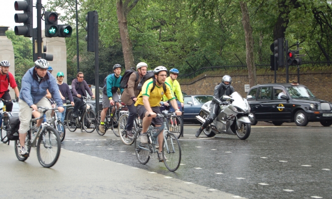
View slides
Watch video:
Some researchers have tried to categorize cyclists’ levels of traffic stress utilizing facility or traffic data that can be readily measured in the field, such as motorized travel lanes, travel speeds, and type of bicycle infrastructure.
This seminar will present data and modeling results utilizing two novel data sources:
(a) real-world, on-road measurements of physiological stress as cyclists...
Read more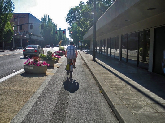
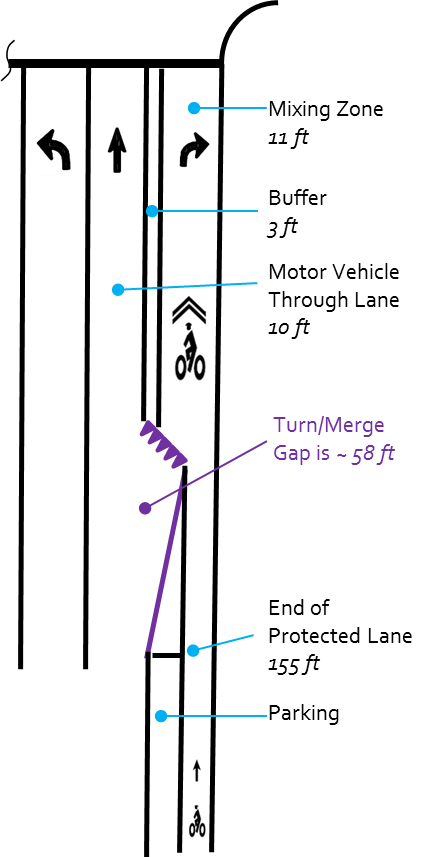
Summary: The most recent edition of the Highway Capacity Manual (HCM) contains analysis procedures for measuring the level-of-service (LOS), also referred to as quality of service, provided by an urban roadway to bicyclists. The method uses different design and operating features of the roadway segment (e.g. width, motor vehicle volumes and speeds) to assess an LOS grade of A (best) to F (worst). These procedures are used by planners and engineers to recommend how existing streets could be retrofitted or new streets designed to better serve people on bicycles (and other modes). However, the current HCM does not include methods that address protected bike lanes (aka “cycle tracks” or “separated bike lanes”), only conventional striped bike lanes, shoulders, and shared streets. There are other methods for predicting comfort from a bicyclist’s perspective that do consider protected bike lanes, but they are either based only on expert opinion or on surveys in Denmark.
This presentation will describe how to evaluate the level-of-service of a protected bike lane using results from surveys conducted in the United States. The model developed by this project could be used to supplement the current HCM to objectively consider a wider...
Read more