Wildlife everywhere faces a growing challenge: moving safely across an increasingly fragmented landscape. Roads, urban development, and other human-made barriers can make it harder for animals to access food, shelter, and breeding areas, while also increasing the risk of wildlife-vehicle collisions. To address this issue, researchers at Portland State University (PSU) worked on a groundbreaking effort to understand and protect the travel patterns of Oregon’s wildlife.

The Oregon Connectivity Assessment and Mapping Project (OCAMP) was a multi-year collaboration aimed at mapping wild species' habitats and travel corridors across the state. The research team created an interactive Priority Wildlife Connectivity Areas Map of Oregon, which can be used to protect wild animals' ability to move from place to place. The project was funded in part by the Oregon Department of Transportation (ODOT), to help the agency identify and mitigate the impacts of transportation infrastructure on Oregon's wildlife.

ABOUT THE PROJECT 

In June of 2019, the Oregon Legislative Assembly passed House Bill 2834, which mandated that the Oregon Department of Fish and Wildlife (ODFW) develop a Wildlife Corridor Action Plan to provide guidance for the designation and protection of wildlife corridors in Oregon. The bill also directed the Oregon Department of Transportation (ODOT) to establish a program to reduce wildlife-vehicle collisions in areas where wildlife corridors identified in the Wildlife Corridor Action Plan intersect with proposed or existing public roads. 

Rachel Wheat, the Wildlife Connectivity Coordinator for ODFW, was the project coordinator. The PSU research team was led by Martin Lafrenz of the Geography department, Catherine De Rivera of Environmental Sciences and Management, and Daniel Taylor-Rodriguez of the Department of Mathematics and Statistics. Lafrenz is a geomorphologist who studies human alteration of the water cycle and the landscape, De Rivera studies how anthropogenic changes in habitat connectivity affect animal populations and ecosystems, and Taylor-Rodriguex focuses on applying statistical methods to large scale problems, with an emphasis on ecological applications. The research was supported by PSU masters students Amanda Temple, Claire Brumbaugh-Smith, and Alana Simmons, and PhD students Leslie Bliss Ketchum and Jacob Schultz.

A large number of researchers, conservation groups, agencies and others were involved in helping to complete OCAMP – part of Oregon's larger conservation strategy – and the data used in the project came from many sources.

"A lot of biologists worked on this project, and many of them know each other. So we reached out to certain people, and then they reached out to more people. There were a lot of connections that happened, for over a year, and people supplied us with whatever data they had on animal presence or tracking," Lafrenz said. Lafrenz's team mapped out key habitats and travel routes used by different species, and Taylor-Rodriguez's team used the data to ensure that the maps aligned with real-world species movement and habitat use.

CONNECTING SCIENCE TO TRANSPORTATION SOLUTIONS

While the Priority Wildlife Connectivity Areas map has many applications — from land conservation to renewable energy siting — one of the most immediate uses is in transportation planning. ODOT can use this map to identify road segments that pose the greatest risk for wildlife-vehicle collisions and determine the best locations for wildlife crossings, such as underpasses or overpasses.

Wildlife-vehicle collisions are not only a danger to animals but can also endanger human safety, and can be costly. Strategic planning informed by OCAMP data means transportation agencies can reduce these risks while supporting Oregon’s biodiversity.

In the past, connectivity mapping in Oregon relied heavily on expert opinion, which left decision-makers without the robust data needed to guide policy and planning. The OCAMP project filled a major knowledge gap, with science-based connectivity models for 54 species representing different movement patterns and habitat needs. These models were combined to create the Priority Wildlife Connectivity Areas Map, which offers a statewide picture of the most critical areas for wildlife movement.

"We used tracking data where we had it, and presence and absence data to validate where the animals were. Then we put all the species together. In the final map, what you notice about it is that it's not for a particular species. It's just animal corridors, generalized. If we are really interested in a specific animal, we can always drill back in the data. But what the Legislature wanted was just a map of animal corridors in general that they could use to say, Okay, you're going to do this project. It's going to impact this corridor. So you need to put some kind of a crossing structure or fencing or some sort of mitigation," Lafrenz said.

WHO CAN USE THIS RESEARCH?

"Now that we have this information, the next big step is to shift into implementation. So how do we make sure that this tool is being used effectively? There are a lot of ways that we've done that, within the State government specifically. We're working with ODOT, to make them aware of where those Priority Wildlife Connectivity Areas intersect with our state highway system. We're also working with the Department of Land Conservation and Development, to guide siting and mitigation for new developments," Wheat said. 

ODFW has presented the Priority Wildlife Connectivity Areas map and tools to organizations including the Association of Oregon Counties and the League of Oregon Cities, as well as Federal land management agency partners.

"There are applications for the Bureau of Land Management, the U.S. Forest Service, the Fish and Wildlife Service, Land Trusts, soil and water conservation districts, watershed councils; basically anyone that's working in the conservation realm can benefit from this specific tool. There are also use cases for members of the public," Wheat said.

A paper by the research team, Visualizing Connectivity for Wildlife in a World Without Roads, was published in the journal Frontiers in Environmental Science.

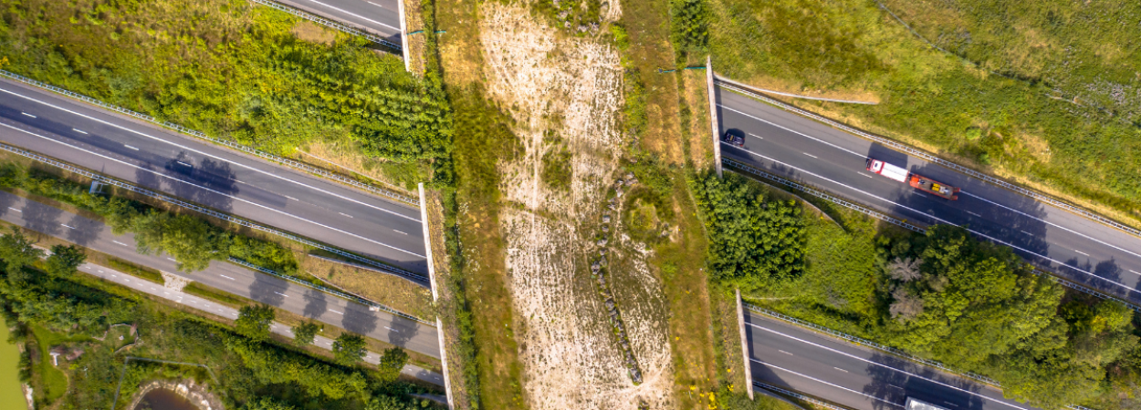
"In that paper, we took southwestern Oregon and erased all the roads. And then we reran our model and compared, where would animals move if there were no roads as opposed to where we think they're moving now? We found that roads had a strong impact on connectivity. Roads influenced connectivity well beyond the footprint of the roadway," Lafrenz said.

Modeling wildlife movement in the absence of existing roads allowed for critical evaluation of where mitigation activities, such as wildlife crossing structures and fencing, could be most beneficial. This novel approach has practical applications for increasing connectivity for wildlife across roads. The high-resolution Priority Wildlife Connectivity Areas map also represents a new innovation in connectivity mapping; an area in which other states might follow Oregon's lead.

"Other states have engaged in statewide connectivity planning and mapping. One thing that sets OCAMP apart is that we used a much newer modeling approach, with much finer-scale spatial data. A lot of the tools that have been produced in other states in the past are at a very coarse spatial scale.Our maps are at a 30 meter resolution. So you can scale down to very small-scale efforts and get into very fine detail," Wheat said.

HOW INDIVIDUALS CAN HELP

ODFW developed a project specifically for roadkill in Oregon which makes use of data from iNaturalist, an online social network for recording observations of wildlife. 

"One of the things that we get asked a lot in our public communication is, how can the average person help provide information for connectivity? And one of the best ways that we found to do that is with iNaturalist," Wheat said.

The state has some information on where large-bodied wildlife, like deer and elk, are killed on roadways, because their maintenance crews remove them. But ODFW has very little information on smaller-bodied species. That's where iNaturalist comes in.

"Anyone with a cell phone can go out and snap a photo of a roadkill observation that they see. And then we can draw on that information to help identify roadkill hotspots and find the areas where we really need to focus on doing some sort of mitigation, whether that's crossing structures, habitat modification, or fencing to try to keep wildlife from getting killed on the road," Wheat said.

With a wide variety of applications for individuals, organizations, and governments, the Priority Wildlife Connectivity Areas map provides a critical tool for planning a connected future. For PSU researchers, OCAMP is an example of how science can inform policy and deliver real-world benefits.

Projects
1654
Researchers
lafrenz@pdx.edu
dtaylor@pdx.edu

Katherine Keeling graduated from Portland State University (PSU) in 2022 with a Master's in civil engineering. She is now a Senior Analyst in Operations & Finance Planning at TriMet.

Connect with Katherine on LinkedIn

What do you do in your current role, and what does a typical day look like? 

I am a Senior Analyst for Operations & Finance Planning. As this title suggests, my main focus is estimating the operations & maintenance costs associated with a change in transit operations. Depending on the impetus, I might be collaborating with transit planners, maintenance experts, executives, or engineering & construction project managers.

How did your experience at PSU shape your path into the transportation field?

I actually keep my PSU transportation engineering notes at my cubicle desk! When I joined a team of analysts, I felt lacking in my understanding of data structures. But I decided to lean into my experience as a researcher to vet assumptions/methodologies, elevate the communication of findings, and to integrate scholarly knowledge into the interpretation of TriMet’s internal data. This became my professional voice!

What advice would you give to current students or recent grads interested in a career in transportation? 

Don’t let fear hold you back from asking all the questions that you need answered! For me, it was tough to be vulnerable enough to ask questions in a large meetings with seasoned professionals, but demonstrating a genuine intent to understand and engage will always pay off! Plus, transportation folks appreciate enthusiasm and heart, not just technical skills.

What’s one project or accomplishment you’re especially proud of in your career so far?

A fun project was drumming up ridership studies to help TriMet negotiate a Ticket-to-Ride campaign with Providence Park; now any Timbers/Thorns/concert ticket is valid fare on event days! It’s a fun way to make transit a part of people’s memories.

Photo courtesy of TriMet. This is an installment in a Transportation Alumni Highlight series, showcasing Portland State University (PSU) graduates who are making a difference in the world of transportation. 

Portland State University's Transportation Research and Education Center (TREC) is a multidisciplinary hub for all things transportation. We are home to the Initiative for Bicycle and Pedestrian Innovation (IBPI), the data programs PORTAL and BikePed Portal, the Better Block PSU program, and PSU's membership in PacTrans, the Pacific Northwest Transportation Consortium. Our continuing goal is to produce impactful research and tools for transportation decision makers, expand the diversity and capacity of the workforce, and engage students and professionals through education, seminars, and participation in research. To get updates about what's happening at TREC, sign up for our monthly newsletter or follow us on social media. 

Tags

Portland State University (PSU) students are once again transforming ideas into action through Better Block PSU, a program that brings community-driven transportation and placemaking projects to life. Three Better Block PSU projects made forward strides this year, thanks to teams of students in the Civil and Environmental Engineering Capstone program and the Master of Urban and Regional Planning (MURP) program.

Last year, we reported on two of the projects:

These two have both made additional forward progress, and we also have updates on a third project, in which PSU students improved bicycle and pedestrian access to Vancouver, Washington's Amtrak Station. Read more about each of the projects below, and visit the Better Block PSU page to learn more about the program overall.

Reimagining Sheridan Street

The International School of Portland has been working with Better Block PSU to improve walking and biking access to the school's campus. In 2024, urban planning students engaged with the local community and developed design alternatives. Building upon their work, a team of civil engineering capstone students developed five potential design solutions for the area.

The goals include enhancing pedestrian safety, achieving Americans with Disabilities Act (ADA) compliance, expanding bike lane access, and aligning with the City of Portland’s transportation objectives. Students Derek Leland, Dinah Sosa-Martinez, Mohammad Alenezi, Noosy Alramadhan, and Revanah Polus developed five design options to balance safety improvements, construction feasibility, and aesthetics. They are:

  • Advisory Bike Lane: Enhances connectivity and promotes alternative transportation by delineating space for cyclists.
  • Continuous Sidewalk: Provides a safe, accessible, ADA-compliant pedestrian pathway by connecting fragmented sidewalks and adding crosswalks.
  • Three-Way Stop: Slows traffic and improves pedestrian visibility at a key intersection near ISP.
  • Bike Exit off Harrison Street: Facilitates smoother transitions for cyclists between bike paths and sidewalks, encouraging cycling.
  • Temporary Traffic Control (TTC) plan: Implemented as a first phase to test interim solutions and raise awareness for long-term improvements.

Bodo Heiliger, Head of the International School, expressed gratitude for the team's work. "Your presentation was on-point, and you truly have formed the foundation for us to move this project forward," Heiliger said.

Bridgeless Burnside

Building upon last year's reimagining of Burnside street done by PSU urban planning students, this project was picked up and moved forward by a Masters in Urban and Regional Planning (MURP) workshop team. Students Michael AzierskiBrian Bill, Eric Gasper, Alex GillJackson Morrison, and Michel Rojas developed plans to create a multimodal corridor which would highlight the cultural and economic amenities of West Burnside Street during the upcoming Burnside Bridge closure.

The goals of the project were to create a pedestrian-friendly corridor, support economic and cultural vitality, enhance community identity in the neighborhood, and prioritize historically marginalized communities and mitigate displacement. Working with neighborhood stakeholders and cultural organizations, the MURP team held several community engagement charrettes and developed a set of recommendations.

For the "bridgeless phase" of Burnside, which is expected to be between 2028 and 2033, the team developed designs to activate West Burnside and reduce economic and cultural disruptions during the bridge closure. These include a temporary plaza between 2nd and 2rd Avenues, with street furniture, planter boxes, and wayfinding signage; and a street plaza in the northbound right turn lane on 4th Avenue. This would convert an empty lot into a flexible program space for cultural events. The team also recommended sites for specific street treatments including raised intersections, bike lanes, bus-only lanes, new bike boxes and bus stops, and other infrastructure improvements. 

Once the new bridge is in place, a second set of designs address longstanding safety and livability issues and bring lasting activation to the space. On a network level, the changes are aimed at improving connectivity and safety across the entire project focus area, while improving comfort and safety at key intersection crossings. The "New Bridge Phase" of the project includes changes to Broadway including additional tree canopy, murals and public art, a planter-box community garden, and a small structure with restrooms, power access, and other amenities. Meanwhile, 10th Avenue would see a priority placed on foot traffic and a set of pocket parts, shade structures, and other amenities to make the space more inviting and welcoming to pedestrians.

See the group's final public presentation and learn about other 2025 MURP workshop projects.

Vancouver Amtrak Station

Working with Better Block PDX on behalf of the City of Vancouver, WA, a team of civil engineering students focused their capstone project on improving pedestrian and bicycle access to the Vancouver Amtrak Station. Students Valentina Castellanoes Ramirez, Matthew Samsom, Ike Agum, and Blu Luz began with a thorough analysis of existing site conditions and stakeholder needs, then evaluated a range of design alternatives.

The study area includes two primary corridors connecting the Amtrak station—located near the Esther Short neighborhood and Columbia River—to downtown Vancouver and the waterfront district. Current conditions present challenges such as inadequate pedestrian and bicycle infrastructure, non-compliant Americans with Disabilities Act (ADA) ramps, and poor stormwater management. The project aimed to enhance multimodal access, improve safety, and create a more inclusive and efficient experience for all users.

The team developed multiple design alternatives with varying costs, lifespans, and feasibility. Their final recommendations prioritize a set of low-cost, easily implemented improvements—such as signage, wayfinding aids, shared lane markings (sharrows), and visual cues—to address immediate connectivity and safety issues while laying the groundwork for future infrastructure investments.

See their final Design Report for more details.

Value For Community Partners

Working with the Better Block PSU program gives community organizations the chance to test bold ideas for safer, more vibrant streets with the support of PSU students and faculty. Through hands-on design, tactical urbanism projects, and community engagement, organizations gain both a proof of concept and the momentum needed to advocate for lasting change. PSU students' work on the Bridgeless Burnside project has been included in the Governor's Central City taskforce report as well as Portland Bureau of Transportation (PBOT) workplans.

"The students' work completed in USP 465/565, USP 511, and culminating in the Bridgeless to Better Burnside MURP Workshop project has continued to generate positive conversations amongst elected leaders and staff," said Ryan Hashagen, Better Block PDX Managing Director.

Interested in having PSU students take on design challenges for your neighborhood? The Better Block PSU program has an annual call for community organizations to reimagine their streets and underused public spaces in a way to bring people together and reclaim it for their community’s future. Join the Better Block PSU email list to be notified when the next RFP opens in early 2026.

Value For Students

For students, Better Block PSU offers real-world experience in urban design and community engagement, allowing them to apply classroom knowledge to hands-on projects. They gain valuable skills in collaboration, project management, and placemaking while being able to make a tangible impact on local neighborhoods.

"Reminiscing on my time in college, the BetterBlockPDX classes were by far the most impactful and inspiring courses I have taken," said Steven Lowe, who worked on the Better Routes to International School project. 

"Working with Better Block PSU was one of the most educational parts of my planning education. I gained real-world experience interpreting planning documents like the zoning code, city plans and initiatives, and design guidelines. I’ve successfully referenced this work in cover letters, and it’s been extremely helpful to have concrete experiences to draw from," said Michael Azierski, a member of the Bridgeless Burnside MURP team. 

"The  Better Block PSU program offered everything I hoped for in terms of building skills in research, writing, and design, and the opportunity to apply theories from graduate courses to a real and immediate planning challenge was invaluable. Beyond that, I was able to expand my network of activists and changemakers in the Portland area and get a glimpse of the social and political forces that really make things happen," said Eric Gasper, another member of the MURP team.

The latest updates from these three projects underscore how Better Block PSU continues to serve as a powerful bridge between academia and community, helping Portland State fulfill its mission to Let Knowledge Serve The City and helping neighborhoods envision safer, more inclusive, and more vibrant public spaces.

The 2025 Portland State University (PSU) Sustainable Transportation Study Abroad class has returned from Denmark, after an immersive exploration of what it takes to build a city for people rather than cars. Through daily bike and transit tours, lectures, and firsthand observations, students learned that making transportation safe and convenient isn’t about one magic policy; it’s a system of integrated decisions—like Copenhagen’s Finger Plan, its cycle superhighways, and a deeply ingrained culture of biking—that together create a vibrant, livable city.

With support from ScanDesign Foundation, the Sustainable Transportation Study Abroad program aims to introduce students to multimodal transportation and land use applications in an international context. This year's cohort of twelve students, along with instructors John MacArthur and Hau Hagedorn, met with officials from transportation organizations like the Danish Road Directorate and consultancy firms Raw Mobility and Niels Hoe 360 Consulting. Students drew comparisons between Copenhagen and U.S. cities, experiencing firsthand what it was like to get around by walking, bikes and transit in Copenhagen. Along the way, they faced challenges—navigating foreign infrastructure, accessibility issues, even personal injuries—and discovered that livable cities require more than good design: they demand empathy and inclusion.

Accessibility in a Cycling City

Phoebe Park is pursuing a masters of science in urban and regional planning from Temple University. She is pursuing a Master's degree to better understand how to advocate for the disabled community in transportation planning. As an ambulatory wheelchair user, Park made firsthand observations of the accessibility of the infrastructure around Copenhagen which provided valuable insights into the challenges faced by wheelchair users in a city celebrated for its bike-friendly design.

"The first day in Copenhagen, I noticed that there weren't always sidewalk curb cuts, and where there were curb cuts, they were not easy to use," Park said.

She also noted several accessibility barriers throughout the transit system, including broken elevators, non-functional powered bus ramps, and frequent inconsistent heights between boarding platforms and vehicle floors. However, the city remains in motion, as residents work around the gaps in access.

"There are many other mobility aids used on the sidewalks, whether it be a smooth pavement or a cobblestone lined street. From strollers to walkers, the disabled people and young children are out and about!" Park said.

Learning from Copenhagen—and Bringing Ideas Home

Beyond experiencing the infrastructure firsthand, students completed assignments that encouraged critical comparisons between Copenhagen and U.S. cities. One assignment was to compare the Copenhagen Bicycling Strategy with a city bike plan for anywhere in the United States. Aiden Moreno, a fourth-year urban studies and planning student at PSU, compared Copenhagen's bike plan with Seattle's and found key differences.

“Seattle’s plan reads like a legal document, whereas Copenhagen’s is short, clear, and focused on achievable goals,” Moreno said. “Both plans address more than infrastructure, including culture and comfort. But Copenhagen’s vision-driven approach is easier for the public to understand and support.”

While comparing plans revealed clear differences in approach, experiencing transportation systems firsthand added another layer of understanding for Moreno. Seeing how policies played out in real life reinforced the idea that context matters as much as design.

"Each city that we visited had a different culture, different political outlook, and each ended up with different infrastructure. Even in cities with the same infrastructure, the way residents interacted with it and how the city managed it differed based on local preferences. What this meant to me in terms of application is that while planners should still push best practices and standards improvement, the local community should inform the design and planning of infrastructure the most. I think this idea in particular could be very beneficial in Seattle," Moreno said.

Other lessons went beyond cycling. Students explored how Copenhagen’s Finger Plan curbs sprawl by concentrating development along five railway lines. “The Finger Plan has resulted in cities surrounding Copenhagen having their own distinct character and uncongested skylines, without being so spread out that anyone has to walk more than 15 minutes to the train station,” said Grace Alston, a PSU master’s student and intern at the Portland Bureau of Transportation. “Denmark has found the harmonious space between urban development and environmental preservation.”

For Future Churchill, a fourth-year planning student and Portland Aerial Tram operator, Copenhagen’s cycling infrastructure left a strong impression. His top takeaways: raised bike lanes, wide spaces for passing, and cycle superhighways that stretch for miles.

"I rode ten miles along a superhighway south of Copenhagen to visit the southern shore. They are designed to have as few interruptions as possible, which is the primary reason I find them particularly comfortable. Reducing the number of intersections also increases safety, given that many bicycle accidents take place at intersections. My trip was basically uninterrupted for nearly six miles!" Churchill said.

The trip highlighted key takeaways that apply back home: prioritize protected bike lanes, design intersections for safety, engage communities in planning, and connect transportation to housing and climate strategies. Most importantly, students returned with a sense of possibility: U.S. cities may have a long way to go, but the building blocks for vibrant, human-scale communities already exist—they just need champions to bring them together.

Learn more about the Sustainable Transportation Study Abroad program, see more photos from this year, or sign up to be notified when applications open for 2026.

Portland State University's Class of 2025 celebrated its commencement ceremonies this past weekend, and we'd like to take a moment to highlight two graduates of the Toulan School of Urban Studies & Planning who devoted their time at PSU to improving the accessibility of transportation services.

Minju Song and Jules Plotts each focused their graduate studies on addressing transportation challenges for particular communities: Song's PhD dissertation examined ride-hailing as a potential solution for older adults who can no longer drive, and Plotts' masters thesis focused on non-daytime shift workers and their access to transit. TREC is proud to congratulate both of these outstanding grads, and looking forward to seeing their next chapter!

Jules Mai Plotts received her masters in Urban Studies, and is now doing a regional planning internship at Metro. She hopes her future career will make an impact on climate and equity. Connect with Jules on LinkedIn

Minju Song (nee Kim) received her PhD in Urban Studies, and is now looking for research or planning roles where she can continue working on transportation equity and accessibility. Connect with Minju on LinkedIn

Learn more about each of these two outstanding grads below.

Jules Mai Plotts

ThesisGeography of Non-Daytime Work and Employer-Centered Transit Accessibility 
Data DashboardNightshift Transit Explorer

As a Masters student in Urban Studies, with a focus on applied research in transportation, Jules developed a keen interest in the role data plays in improving transportation equity. For her thesis she modeled network accessibility to shift-work-related jobs by nighttime/off-peak transit using data from General Transit Feed Specifications (GTFS) and Longitudinal Employer-Household Dynamics (LEHD).

She also created a dashboard, the Nightshift Transit Explorer, that lets users visualize case studies on a map and see the locations of large employers and their workforces. This type of tool could help transit agencies or large employers develop predictive scheduling or add new routes where they are most needed. For example, a large employer in an isolated industrial area would require different solutions from a clustering of small food service employers along an established transit corridor.

People with these hours work in a variety of industries including transportation, warehousing, food service, and healthcare, yet many transportation models focus on "peak" commute times based on a 9-5 office work schedule. Experiencing evening shift work firsthand inspired Plotts to adopt this research topic.

"I used to work out in Beaverton at a restaurant. I would get out late, and my commute back via transit was sometimes good, and sometimes just terrible. It wasn't very far—maybe ten minutes by car—but it would be over an hour sometimes, just to get back. I remember this very clearly: once I missed my transfer bus, so I was kind of stranded waiting for the next one. I remember this guy with an orange vest, he looked like he had come from a construction site. He was like, 'Yeah, they don't really make these schedules for us.' So this is clearly a problem that not just restaurant workers have, but other people, too," Plotts said.

Her thesis looked at the geography of non-daytime work and then modeled transit accessibility. Unlike traditional models that start from home locations, this approach starts from the job site to ask: Who can reach this job by transit—and when?

"Lower wage workers tend to work different shifts. And so a peak hour analysis might not be the best to meet their needs," Plotts said.

Minju Song

DissertationIs Ride-Hailing a Potential Solution for Older Adults After Driving Cessation? The Role of Objective and Perceived Accessibility

Minju Song received a PhD in Urban Studies as well as a graduate certificate program from the PSU Institute on Aging. She received a Master's degree in Transportation Studies from Seoul National University and studied in Urban Planning for Bachelor from Chung-Ang University from South Korea.

Her doctoral research focused on alternative transportation options for older adults, particularly after they stop driving. With services like Uber and Lyft becoming common, Song wanted to understand whether these new transportation options could actually work for older adults. Her research looked at this from both angles—analyzing the quantitative data about neighborhoods and transit infrastructure, and listening to real stories from older adults about their experiences and opinions about ride-hailing. Her work explored the gap between objective accessibility and perceived accessibility.

"I want to help make transportation systems more inclusive, especially for those often left out of planning decisions. Right now, a lot of transportation systems are designed assuming everyone can drive and has easy access to everything. But what about older adults who can't drive anymore? Or people who can't afford a car?" Song said.

Now that she has finished school, Song hopes to continue working on transportation equity and access.

"Through my research, I've learned that small things—like how an app is designed or how older adults are introduced to new transportation options—can make a huge difference in someone's ability to get around. I hope to keep working on projects that prioritize actual users' needs, whether that's through research, policy, or direct community work," Song said.

Portland State University's Transportation Research and Education Center (TREC) is a multidisciplinary hub for all things transportation. We are home to the Initiative for Bicycle and Pedestrian Innovation (IBPI), the data programs PORTAL and BikePed Portal, the Better Block PSU program, and PSU's membership in PacTrans, the Pacific Northwest Transportation Consortium. Our continuing goal is to produce impactful research and tools for transportation decision makers, expand the diversity and capacity of the workforce, and engage students and professionals through education, seminars, and participation in research. To get updates about what's happening at TREC, sign up for our monthly newsletter or follow us on social media. 

Tags

A report by Portland State University (PSU) researchers offers an improved framework for assessing the seismic risk of transportation structures. Earthquake preparedness is a high priority for the Pacific Northwest, and cities and state agencies will benefit from having a more accurate and consistent way to prepare.

In collaboration with the Oregon Department of Transportation (ODOT) and the Federal Highway Administration (FHWA), the researchers developed a method to manage bridges and tunnels using various data sources and rigorous risk definitions. Traditionally, decisions about retrofitting existing structures have been based on expert opinion, past experience, or limited data, which can be subjective and incomplete for the estimation of seismic risk. This new research developed an automated method, underpinned by scientific understanding on seismic hazard and structural fragility, to make risk assessments more accurate, consistent, and helpful for choosing which retrofitting interventions should be a priority.

The research was sponsored by the FHWA Office of Bridges and Structures, and conducted by David Yang, Arash Khosravifar, and Diane Moug of PSU's Maseeh College of Engineering and Computer Science and Avinash Unnikrishnan at University of Alabama, Birmingham (former faculty at PSU) .

"Previously a lot of risk assessments were based on empirical assumptions or panel sessions where engineers sit together and try to evaluate what will be the hazard scenarios for our region, what are their frequencies, and what are the damage likelihood and extent to our transportation structures.. While this is useful, latest advances on earthquake engineering and  performance-based engineering can offer more reliable ways to assess risk," Yang said, “The challenge is how these latest advances can be incorporated into the asset management practice and bridge management systems (BMSs) used by transportation agencies. Our research aims to fill in this research gap.”

Existing BMSs use a table of expert-elicited hazard scenarios. Keeping the format of a risk table, the new method selects scenarios, evaluates likelihoods and consequences of scenarios, and weights their importance to overall risks, all based on well established information on hazard and structural characteristics from e.g., USGS and FEMA. This makes it more consistent and objective.

WHO CAN USE THIS RESEARCH?

Who are the stakeholders for accurate seismic risk assessment? It encompasses many: communities at risk, structural engineers, insurance and reinsurance industries, and various federal, state, and local agencies, such as the Federal Emergency Management Agency (FEMA), ODOT, Portland Bureau of Transportation (PBOT), and state and local emergency management offices.

The framework developed by the team accounts for direct monetary impacts due to both deterioration and natural disasters, as well as for indirect impacts on the functionality of highway networks. This lets various stakeholders identify which bridges, tunnels, or routes pose the greatest risk to the system performance — and make smarter, more cost-effective decisions to keep people and transportation networks safe.

The methods developed by the research team can handle large, complex networks and account for low-probability but high-impact events, and they outperform previous, more subjective approaches in both accuracy and robustness.

To facilitate application,  the model's source code is shared with FHWA and is accessible by agencies who wish to use it.

While this report focuses on earthquakes, the general theory can be adapted for other hazards as well, making it potentially useful for a wide variety of resilience efforts.

The report, "Framework and Methodology for Risk-Based Bridge and Tunnel Asset Management: Objective Risk Assessment and Network Level Evaluation," represents the first of a two-phase research project aimed at assessing and managing the condition and risk of bridges and tunnels. In the second phase, the research team will prepare a repository of risk tables for all the bridges in Oregon, creating a case study for the new method and helping ODOT to prioritize retrofits and repairs.

Portland State University's Transportation Research and Education Center (TREC) is a multidisciplinary hub for all things transportation. We are home to the Initiative for Bicycle and Pedestrian Innovation (IBPI), the data programs PORTAL and BikePed Portal, the Better Block PSU program, and PSU's membership in PacTrans, the Pacific Northwest Transportation Consortium. Our continuing goal is to produce impactful research and tools for transportation decision makers, expand the diversity and capacity of the workforce, and engage students and professionals through education, seminars, and participation in research. To get updates about what's happening at TREC, sign up for our monthly newsletter or follow us on social media. 

Projects
1557
Researchers
david.yang@pdx.edu
dmoug@pdx.edu
karash@pdx.edu

In his first public presentation at Portland State University (PSU) since returning to Portland, former U.S. Congressman Earl Blumenauer spoke with an audience of about fifty students, faculty, and community members on May 17 about transportation funding.

Drawing from years of government experience at all levels, Blumenauer outlined the funding challenges faced by transportation agencies in Oregon and beyond.

He started by referring to a saying that for every problem there is often an elegant solution that is wrong. Raising the gas tax, he said, is such an “elegant solution.” The impact of raising the gas tax is less significant now than it was 30 years ago. 

“Paying by gallons is no longer rational with electrification,” he pointed out, instead advocating for a road user charge. Road user charges, he argues, are more elegant, more fair, and can dramatically improve the driving experience. 

Blumenauer reminded the crowd that Oregon was the first state to adopt a gas tax, in 1919. Our state has been a pioneer in transportation innovation, and it may be time for us to once again lead by example.

Acknowledging that some road users have concerns about the privacy of their location data, Blumenauer emphasized the importance of letting people have control over their personal information and providing options for how to pay the user charges. Giving people information to make informed decisions is crucial, he said, so that members of the public understand why there is a need for an updated way to pay for infrastructure and what the options are.

A question-and-answer session with audience members followed the talk. Topics discussed included vehicle design, the costs and benefits of vehicle electrification, how freight factors into the funding discussion, and ways to support local roads.

Now that he's back in Portland, Blumenauer is serving as a Senior Fellow and Special Advisor to the Portland State University President and as a Presidential Fellow of the Institute of Portland Metropolitan Studies. He intends to bring his dedication and experience to bear on addressing the local and regional issues he cares passionately about, including transportation finance. IMS and TREC will be working together on the topic throughout the next academic year. 

Portland State University's Transportation Research and Education Center (TREC) is a multidisciplinary hub for all things transportation. We are home to the Initiative for Bicycle and Pedestrian Innovation (IBPI), the data programs PORTAL and BikePed Portal, the Better Block PSU program, and PSU's membership in PacTrans, the Pacific Northwest Transportation Consortium. Our continuing goal is to produce impactful research and tools for transportation decision makers, expand the diversity and capacity of the workforce, and engage students and professionals through education, seminars, and participation in research. To get updates about what's happening at TREC, sign up for our monthly newsletter or follow us on social media. 

Nick Foster graduated from Portland State University (PSU) in 2014 with a Master's of Science in civil engineering. He is now a Principal Planner at Kittelson & Associates in Boise, ID. The photo on the left shows a project Nick worked on in Boise. On the right, Nick and his daughter are watching the PSU’s women’s basketball team play in the Big Sky basketball tournament.

Connect with Nick on LinkedIn

What do you do in your current role, and what does a typical day look like? 

There’s a wide variety of things I get to do in my current role and no two days are the same! On the technical side, I work on a lot of safety and active transportation focused plans and concept designs. Outside of technical work, I have the opportunity to build relationships with clients and colleagues, develop and execute business strategy (including hiring!), mentor staff, and engage in professional organizations and conferences. During any given day, I’ll spend a little over half my time on project work and the rest of my time connecting with colleagues, working on proposals, talking to students interested in getting into the field, and doing all the other things it takes to make a business run!

How did your experience at PSU shape your path into the transportation field?

I worked at Kittelson for six years before coming to PSU. I came to PSU looking to hone my research skills, learn from professors who were leaders in their field, and take some time to explore technical topics I was interested in outside project work. I was able to use the skills and knowledge I gained from my time at PSU to continue on in safety and active transportation research projects, as well as to help the communities I work with advance their capabilities to safely serve all modes of travel.

What advice would you give to current students or recent grads interested in a career in transportation? 

It’s an incredibly multidisciplinary field that incorporates topics ranging from psychology to pavement design and geotechnical engineering. Take opportunities to gain exposure to all the different facets of the field as you move through schooling and begin your career. Whatever path you ultimately take in transportation, this foundation will make you a better professional. And don’t ever stop learning from others!

What’s one project or accomplishment you’re especially proud of in your career so far?

Building on some of the knowledge I gained from PSU, I’ve had the opportunity to work with local agencies here in Boise to create better infrastructure for people walking, biking, and driving, including planning for and designing the first raised bike lane through downtown Boise. We tried a lot of new things out in the design, so I was excited to see that it had worked out when I took my then 8-year old on it one day and she immediately lit up as we transitioned from a painted bike lane onto it. Oh, and while I have “planner” in my title, there is one set of constructed signing and striping plans out there that has my name on it!

This is an installment in a Transportation Alumni Highlight series, showcasing Portland State University (PSU) graduates who are making a difference in the world of transportation. 

Portland State University's Transportation Research and Education Center (TREC) is a multidisciplinary hub for all things transportation. We are home to the Initiative for Bicycle and Pedestrian Innovation (IBPI), the data programs PORTAL and BikePed Portal, the Better Block PSU program, and PSU's membership in PacTrans, the Pacific Northwest Transportation Consortium. Our continuing goal is to produce impactful research and tools for transportation decision makers, expand the diversity and capacity of the workforce, and engage students and professionals through education, seminars, and participation in research. To get updates about what's happening at TREC, sign up for our monthly newsletter or follow us on social media. 

Tags

The concept of e-bike lending libraries is simple: they allow people to borrow e-bikes – for a few hours or a few months. Borrowing lets people try e-bikes when they're not ready or able to commit to the expense of buying one. By getting people used to riding e-bikes for everyday trips, lending libraries make e-bikes more accessible, reduce vehicle miles traveled (VMT), and advance city and state climate goals.

A new report, "E-bike Lending Libraries: Trends and Practices in The United States," offers a comprehensive scan of e-bike lending libraries across the U.S. Through interviews and surveys, researchers John MacArthur, Joshua Miller, and Isa Swain of Portland State University identified key elements, goals, commonalities and differences among 54 e-bike lending libraries in the United States. The research team also produced an online resource to keep track of them all: the U.S. E-Bike Lending Library Programs Tracker.

Surveys and case studies have demonstrated that e-bike lending programs can effectively shift travel behaviors, increase e-bike purchases, and build public awareness. Studies have also shown that e-bike users are more likely to replace car trips compared to traditional bike users. By integrating e-bikes into local transportation systems, cities can mitigate automobile congestion and improve overall urban mobility.

This study was led by MacArthur, who is TREC's Sustainable Transportation Program Manager, and supported by funding from the Oregon Department of Transportation (ODOT). Joshua Miller is a Master of Urban and Regional Planning (MURP) student, and Isa Swain is a third-year undergraduate student pursuing a B.S. in Public Health.

TO BUY OR TO BORROW?

The concept of a library that offers something other than books has been growing in popularity in recent years. Many traditional book libraries have begun to complement their services with the addition of a “tool library” or a “library of things” to provide the community with shared resources or assets. 

Some public book libraries even allow patrons to borrow bikes or e-bikes. However, a public book library that contains e-bikes in its catalog is not the only kind of system being considered in this report. While this system certainly can be effective, e-bike lending libraries are not exclusively being offered through existing public libraries. In the report, the authors define an e-bike lending library as any program or system that allows individuals to check out an e-bike for low to no cost for a period of time.

In addition to an overview of existing lending libraries, the report also offers a look at the current e-bike market in the U.S. and e-bike incentive programs. Sales of e-bikes outpaced electric cars and trucks in the past three years, and e-bikes now represent approximately 20% of the bicycle market. Incentive programs provide financial assistance to people who want to purchase e-bikes, and pairing a lending library with an incentive program can be an effective means of outreach and encouragement

MacArthur led a separate project in 2022 to create an online e-bike incentive programs tracker, which is soon to be updated.

THREE MAIN TYPES OF LENDING LIBRARIES

E-bike Lending Library Models: Try before you buy, community resource, and For Hire.

Of the 54 programs they scanned, the researchers found that they tended to operate under one of three main models: community resource libraries, ride-to-purchase programs, and long-term access programs.

Community resource libraries prioritize providing free or low-cost e-bikes as shared transportation assets, often targeting underserved populations.

Ride-to-purchase programs focus on encouraging eventual e-bike purchases, by offering users the chance to test various models and explore financial incentives, such as rebates.

Long-term access programs, often subsidized by grants, lease e-bikes at below-market rates to community members, enabling them to integrate e-bikes into their daily routines over extended periods of time.

Community resource programs were the most common, with 28 of the 54 lending libraries built on this model. 

E-BIKE LENDING LIBRARY GOALS

E-bike lending libraries are designed to achieve six overarching goals: sustainability, equity, ownership, utility, recreation, and economic vitality. Most programs address multiple goals, with sustainability, equity, and ownership being the most prevalent. 

The goals of each program shape how e-bike lending libraries are designed and carried out. Programs focused on sustainability aim to cut greenhouse gas emissions by promoting e-bikes as a clean, zero-emission way to travel. Equity-driven programs work to improve access for low-income and underserved communities, helping to remove transportation barriers. Ownership-focused programs let people borrow e-bikes over time to reduce cost and knowledge gaps, with the goal of eventually supporting personal e-bike ownership. Other programs aim to promote the use of e-bikes for recreationutility (like running errands or cargo delivery), and economic vitality by supporting tourism and local businesses.

The report offers a much more in-depth discussion of how lending libraries set and achieve these goals, as well as examples of different approaches to administration and funding. As e-bike lending library programs are becoming more popular, communities across the country are looking for ways to fund these programs. Out of the 54 lending libraries found in the scan, the researchers were able to determine funding for 43 libraries. Thirty-six (36) libraries received funding from a grant, and five received funding from donations. The rest received funding from sponsorships or private funds. 

Community organizations interested in forming a new e-bike lending library, or growing an existing one, will find a wealth of resources and insights in the report.

Learn more about the project: E-bike Lending Libraries: Trends and Practices in the United States.

Photo by Forth

Portland State University's Transportation Research and Education Center (TREC) is a multidisciplinary hub for all things transportation. We are home to the Initiative for Bicycle and Pedestrian Innovation (IBPI), the data programs PORTAL and BikePed Portal, the Better Block PSU program, and PSU's membership in PacTrans, the Pacific Northwest Transportation Consortium. Our continuing goal is to produce impactful research and tools for transportation decision makers, expand the diversity and capacity of the workforce, and engage students and professionals through education, seminars, and participation in research. To get updates about what's happening at TREC, sign up for our monthly newsletter or follow us on social media. 

Projects
1639
Researchers
macarthur@pdx.edu

Tags