
PSU students develop transportation app to make trips easier
Posted on September 25, 2013
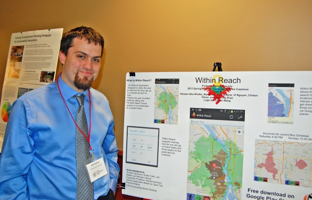
Kyle Greene presented Within Reach at the 2013 Oregon Transportation Summit
Imagine you are in downtown Portland, you have a meeting in 45 minutes, and you are hungry. You have a bike, but where could you get food and still make it to your meeting on time? What if you walked? Or took transit?
WithinReach is an Android-phone App designed to answer these types of questions. It was created by six PSU students for the Computer Science Capstone program.
The app provides the user with a map of locations reachable by foot, bike or transit from their current location, within a time period that the user can specify. Users can also search for nearby locations of interest via integration with Google places, and set a specific date/time/location for future planning.
The Capstone project was proposed by OTREC researchers Kristin Tufte, Jon Makler, and Morgan Harvey, who specified the functionality they wanted the program to have but left it up to students whether to develop it for a web-based platform or as a smartphone app.
When group members Kyle Greene, Alex Flyte, Clinton Olson, Haneen Abu-Khater, Hanrong Zhao, and Vi Nguyen heard about the transportation-focused project, they jumped at the chance to work on it, excited about the prospect of developing an application that would be useful in a real world environment.
“Collectively we decided that a mobile application would be where this type of program would be most useful,” said Greene, who presented the group’s project during the 2013 Oregon Transpotation Summit on Monday, September 16. “We made a very early prototype so that we knew how to make all the various bits of the program talk to each other and so we could start testing/improving the user interface.”
To create the app, they used Eclipse IDE (integrated development environment) with a special Android development plug in. This had the advantage of being cross-platform so everyone was able to develop on their own machine. Other than using Eclipse, the students did not use an app-creation tool and wrote most of the code from scratch. They made use of the Google Maps API (application programming interface) and the Google Places API, as well as custom-adapting Open Trip Planner Analyst (OTPA) to provide graphics for different transportation modes.
“The development of a quick prototype was a key factor in our success,” group member Clinton Olson said. “Because we did not know ahead of time exactly how to proceed with developing a mobile application of this kind, making a quick prototype and then adding incremental features and functionality to the prototype allowed us maximal flexibility if things went awry.”
The app took about 3 months to develop, and is available for free download on the Google Play store.
Olson believes that there is some great potential in the future development of Within Reach. As it currently stands, it is only applicable to the Portland Metro area (parts of Vancouver and Salem are supported as well) and it could be extended to other areas of the country as well. There are also many different external services that could be integrated into the application to make it more useful. TriMet Trip Planner could provide users with step-by-step directions on how to get to their destination on the public transit system, and integration with Yelp could provide users with reviews and other information on areas of interest within their time constrained travel zone.
Within Reach is open source and loaded up on GitHub, so anyone who wants to extend the functionality of the app for their own purposes can download the code and extend the application for their area or provide new functionality for the application.