Seminar or Event
Friday Seminars
SPEAKERS
Jason Anderson, PSU
COST
Free and open to the public

Friday Transportation Seminars at Portland State University have been a tradition since 2000. We've opened up PSU Transportation Seminars to other days of the week, but the format is the same: Feel free to bring your lunch! If you can't join us in person, you can always watch online via Zoom.

PRESENTATION ARCHIVE

THE TOPIC 

North Lombard Street/US-30 Bypass is a critical corridor in North Portland, serving both commercial and residential interests. This corridor is also ranked 11th in terms of fatal and serious injury crashes in Portland. The Oregon Department of Transportation and the Portland Bureau of Transportation undertook a reconfiguration to improve multimodal safety and accessibility for all users. The reconfiguration happened between North Fiske Ave and North Boston Ave. Improvements included additional curb ramps that meet ADA standards, safer crosswalks with fewer lanes to cross, buffered bike lanes, new pavement and center turn lanes, traffic signals, and RRFBs and median refuge islands.

This seminar will present the results of a before and after evaluation focused on vehicle-pedestrian conflicts, pedestrian crossing volumes, pedestrian delay, vehicle throughput and vehicle miles traveled (VMT), vehicle speed, and vehicle travel time.

KEY LEARNING OUTCOMES

  • Impact of a multimodal project on safety measures.
  • Impact of a multimodal project on travel time.
  • Recommendations for before-after studies.

SPEAKER

Jason Anderson, Portland State University

Dr. Jason C. Anderson is a senior research associate and adjunct instructor at Portland State University. Dr. Anderson’s expertise is in data analytics, with an emphasis on transportation safety, travel behavior, big data, and transportation policy. His work on policy-related research has led Oregon and local agencies to develop and maintain safety programs and treatments for freight transportation, active transportation, and speeding mitigation. Dr. Anderson’s research on transportation safety has helped advance fundamental knowledge on various factors that influence the risk and severity of freight and active transportation-related crashes, and the impacts of speed limit regulatory changes on driver behavior and safety. Dr. Anderson focuses on innovative strategies to generate multidisciplinary solutions to technology-driven questions related to transportation engineering. Dr. Anderson is also an avid sports fan who does not miss a Sacramento Kings game or a NASCAR race.

PROFESSIONAL DEVELOPMENT

This 60-minute seminar is eligible for 1 hour of professional development credit for AICP (see our provider summary). We can provide an electronic attendance certificate for other types of certification maintenance.

Portland State University's Transportation Research and Education Center (TREC) is home to the U.S. DOT funded National Institute for Transportation and Communities (NITC), the Initiative for Bicycle and Pedestrian Innovation (IBPI), PORTAL, BikePed Portal and other transportation grants and programs. We produce impactful research and tools for transportation decision makers, expand the diversity and capacity of the workforce, and engage students and professionals through education and participation in research.

LOCATION
Vanport Building room 269
CREDIT
PDH: 1 | AICP: 1
Is Visiting Scholar
Off
DATE
-

Contact us at asktrec@pdx.edu or call the front desk at 503-725-2896.

Our office is in the Fourth Avenue Building at PSU 1900 SW Fourth Ave., Suite 175. Need to send mail? 

Send to:
TREC
P.O. Box 751
Portland, OR 97207

Explore curriculum modules for transportation engineering, planning, and K-12 students.

University Curriculum: Transportation Planning 

PROJECTWHAT IS INCLUDED IN THE FINAL REPORT?LEVELLEAD EDUCATOR
Equity in Travel BehaviorMaterials ForthcomingUndergraduate/GraduateAnne Brown, University of Oregon
Launching the Wasatch Transportation AcademyCurriculum Handbook; Course Implementation Guide Community Member/Professional Nathan McNeil, Portland State University 
Collaborative Regional Planning: Tools and Techniques for Teaching Collaborative Regional Planning to Enhance Livability and Sustainable TransportationExample scenarios for planners in gateway communitiesGraduate/ProfessionalDanya Rumore, University of Utah
Introduction to Scientific Computing for Planners, Engineers, and ScientistsSyllabus; Readings; Lessons; Exercises; ResourcesGraduate/ProfessionalLiming Wang, Portland State University
Pedestrian Observation and Data Collection CurriculumLecture slides; Data collection forms; Classroom exercisesUndergraduate/GraduateJennifer Dill, Portland State University
Phase 2 Multimodal Transportation Planning Applications Curriculum for Urban Planning ProgramsSyllabus; Lesson Plans; Grading RubricsUndergraduate/GraduateKristine Williams, University of South Florida
Pedestrian and Transit Oriented DesignCourse Objectives; Methods; Case StudiesGraduateKeith Bartholomew, University of Utah
Multimodal Transportation Planning Curriculum for Urban Planning ProgramsSylliabus; Lesson Plans; Grading Rubrics; Exercises Undergraduate/GraduateKristine Williams, University of South Florida
Strategic Design and Policy for Improving the Livability and Multi-modal Use of U.S. Urban Arterials and Commercial HighwaysStudio Assignments; Syllabus; Supplemental MaterialsGraduateMichael Larice, University of Utah
OLIS Sustainable Transportation ClassCuriculum Synopses; Applied Learning Projects; Pedagogical Outcomes GraduateVicki Elmer, University of Oregon 
Addressing Homeless Encampments on Public Right-of-Way: A Knowledge Transfer ProjectCase Study; Recorded WebinarProfessionalAndree Tremoulet, Portland State University
Enhancing Bicycle and Pedestrian Education through Curriculum and Faculty DevelopmentCurriculum Modules: Presentations, Handouts, Readings, AssignmentsUndergraduate/GraduateLynn Weigand, Portland State University
Electric Vehicle Charging Infrastructure Community Needs AssessmentReport with outcomes from an experiential education programGraduateRobert Parker, University of Oregon
designBridge: Integrating Transportation into Service Learning Design/Build ProjectsActivities and ResourcesUndergraduate/GraduateNico Larco, University of Oregon
Trail Planning & Community Service CurriculumCourse outline, Assignments, Evaluation forms, Student presentationsUndergraduate/GraduateLynn Weigand, Portland State University
designBridge: Integrating Transportation into Service Learning Design/Build ProjectsReport with outcomes from an experiential education programUndergraduate/GraduateNico Larco, University of Oregon
Expanding Service Learning Models in TransportationReport with outcomes from an experiential education programGraduateRobert Parker, University of Oregon
Bicycle and Pedestrian Design Curriculum ExpansionCourse outline, Lab assignmentsUndergraduate/GraduateLynn Weigand, Portland State University
City Design Lecture Series: Linking Transportation and Land Use PlanningTranscripts from a lecture seriesUndergraduate/GraduateMark Gillem, University of Oregon
Bicycle and Pedestrian Education ProgramCurriculum ModulesUndergraduate/GraduateLynn Weigand, Portland State University
Linking Experiential Learning to Community Transportation PlanningReport with outcomes from an experiential education programGraduateRobert Parker, University of Oregon
Road Ecology Course and Seminar SeriesCourse syllabi, Critical reading guide, Assignments, Evaluation formsUndergraduate/GraduateMark Sytsma, Portland State University


University Curriculum: Transportation Engineering


PROJECTWHAT IS INCLUDED?LEVELLEAD EDUCATOR
Instructional Modules for Obtaining Vehicle Dynamics Data with Smartphone SensorsLesson plans, Visual aids, Lab/Field exercisesUndergraduate/GraduateRoger Lindgren, Oregon Institute of Technology
Dynamic Evaluation of Transportation Structures with iPod-Based Data AcquisitionLaboratory modules, Posters and presentationsUndergraduate/GraduateCharles (C.J.) Riley, Oregon Institute of Technology
Graduate-level Civil Engineering Transportation Course DevelopmentCourse outlines, Readings and resourcesGraduateRoger Lindgren, Oregon Institute of Technology
Advanced GIS: Smart TransportationCourse overview, Syllabus, AssignmentsUndergraduate/Graduate Christopher Bone, University of Oregon
Activity-Based Learning Module for Human Factors in the Introductory Transportation Engineering CourseCourse overview, Description of educational activitiesUndergraduateDavid Hurwitz, Oregon State University
Development, Deployment, and Assessment of a New Educational Paradigm for Transportation Professionals and University StudentsReport with outcomes from an experiential education programUndergraduate/GraduateAshley Haire, Portland State University 
Bicycle and Pedestrian Engineering Design Curriculum ExpansionSyllabus, reading listUndergraduate/GraduateAshley Haire, Portland State University
Distribution Logistics CourseCourse overview, Syllabus, Student work excerpts and comments Undergraduate/GraduateMiguel Andres Figliozzi, Portland State University

K-12 Transportation Curriculum

PROJECTWHAT IS INCLUDED?LEVELLEAD EDUCATOR
GIS Training in Transportation And Environmental Justice for Promoting Student Success in STEAM EducationGIS Curriculum Modules for a four-week workshop9-12 gradeJoowon Im, University of Texas at Arlington
S.T.E.A.M. TRAINing: Engaging High School Girls in Transportation and Equity Issues through GISClassroom slide presentations; Lesson plans; Lab activities; Study sheets  9-12 gradeRandy Morris, Portland State University
Closing the Gap: Developing a Transportation Curriculum for the Oregon Young Scholars ProgramCourse overview; Lesson plans; Sample discussion questions8-12 grade Carla Gary, University of Oregon
Project Phenom: A Smart Bike ProjectCourse budget and material list; Complete lesson plans with outlines, assignments, and visual aids6-12 grade Stephen Fickas, University of Oregon
Investigations in TransportationReport with outcomes from an experiential education program3-5 gradeCarol Biskupic Knight, Portland State University
"Big & Awesome Bridges"240 page, full-color book featuring 22 big river railway and roadway bridges in the Portland, OR and Vancouver, WA region.3-5 gradeSharon Wood Wortman and Ed Wortman

Curriculum Terms of Use

The curriculum modules and resources shared here are offered to you conditioned on your acceptance without modifications of the Terms. Your use of the curriculum modules constitutes your agreement to all such Terms.

  • To reproduce or make copies of the modules: any reproductions or copies must contain proper attribution to the National Institute for Transportation and Communities (NITC), and at a minimum, the NITC logo.
  • To distribute the modules or module adaptations: any reproductions or copies must contain proper attribution to NITC, and at a minimum, the NITC logo.
  • To create and reproduce adaptations (work based on the curriculum modules): provided that any such adaptations or changes, including any translation in any medium, takes reasonable steps to clearly label, demarcate or otherwise identify that changes were made to the original modules. For example, a translation could be marked "The original curriculum modules were translated from English to Spanish." If significant adapations are made (e.g. language translation) that may benefit other users, please contact us at asktrec@pdx.edu to determine whether this update could be added to the project resources.

The Pacific Northwest Transportation Consortium (PacTrans) is the Regional University Transportation Center (UTC) for Federal Region 10, housed at University of Washington (UW). In June of 2023, the Infrastructure Investment and Jobs Act (IIJA), or Bipartisan Infrastructure Law (BIL), awarded PacTrans its fourth competitive grant of $15 million over 5 years. With that award, PSU joined PacTrans. The center is a mobility focused University Transportation Center with a theme of, “developing human-centered and transformative multimodal mobility solutions for an equitable Pacific Northwest.” PSU’s participation in PacTrans is managed by the Transportation Research and Education Center (TREC).

Each year, PacTrans provides PSU with $150,000 to fund “small research projects.” Those projects must be selected using a competitive, peer-review process. The Year 3 RFP describes the process for PSU researchers to submit proposals for these funds. PSU plans to award no more than three projects. Therefore, individual project requests should range from $30,000 to $70,000. 

KEY DATES

  • Abstracts due: May 6, 2025, 11:59 pm.
  • Proposals due: June 3, 2025 11:59 pm.
  • Project selection and award documents: August/September 2025
  • Projects begin: September/October 2025
  • Projects end: August 2027

DOCUMENTS

To submit an abstract and proposal, log into PPMS.

See more PSU PacTrans projects.

In recent years, cities and counties all across the United States have invested in bicycle and pedestrian counters. Having reliable data on non-motorized traffic can help jurisdictions make informed decisions about infrastructure investments, measure the effectiveness of biking and walking initiatives, and improve safety. 

But having a bike-ped count program is just the beginning. 

Once counts have been collected, cities face new challenges. How can multiple agencies share data among themselves? How can data be standardized and compared? And what is the most effective way to communicate what the numbers mean?

Enter Bike-Ped Portal, the comprehensive non-motorized data management system for manual and automated non-vehicular multi-modal counts housed at Portland State University (PSU). This specialized data lake and management system is designed to make sharing data—within an agency, with partners at other agencies, and with the public—easily accessible. The newest feature we've added is a regional dashboard for the Portland, OR and Vancouver, WA metropolitan area.

DATA QUALITY

Agencies who use Bike-Ped Portal may have counters from different vendors, or use more than one platform to manage data. That's why Bike-Ped Portal is able to accept data in multiple formats, whether that's a spreadsheet with manual counts, output from automated counters, or APIs such as EcoCounter. Once the system receives new data, it is converted into a standardized format. Quality control tools are available, along with the ability to add correction factors and data annotations.

Registered users have access to all the data in Bike-Ped Portal, making it possible to run almost any type of analysis depending on goals and needs. No matter what the end user is looking to analyze, Bike-Ped Portal's quality checks and tools offer confidence that the underlying data is good. Researchers and practitioners can get what they need from one place, making Bike-Ped Portal a "one stop shop" for raw counts, AADNMT (Average Annual Non- Motorized Traffic), data tools, and visualizations.

For one example of what Bike-Ped Portal can do, TREC Adjunct Research Associate Kyu Ri Kim developed a case study exploring the relationship between volumes, crashes, and speeds. See presentation "Where do Bike/Ped Crashes Occur?" Kim presented this project in a meeting of the PORTAL Users Group (PUG), to be held September 5.

CUSTOM TOOLS AND DASHBOARDS

Bike-Ped Portal does more than reduce the time and effort required to manage multiple data sources, format, standardize, validate, and share data openly. TREC's transportation data team can also build custom analytical tools and dashboards to help data tell a story. Transportation Data Program Manager Tammy Lee, and Senior Research Associate Basem Elazzabi, who head up TREC's transportation data program, work with agencies to build tools which meet their specific needs, help reduce redundancies and standardize reporting.

Portland Region Dashboard

Recently added to Bike-Ped Portal is a dashboard for the Portland, OR and Vancouver, WA metropolitan area. To access this dashboard, visit the explore page and select "regions" on the right, then choose the region. Users can see activity on a particular segment broken down by month, year, and day, or use the map to select individual detectors and counters.

Another example of a regional dashboard is one that the Bike-Ped Portal team created for the Washington, D.C. National Capital Region, working with Virginia Tech and the University of North Carolina Highway Safety Research Center (HSRC). The BikePortal National Capital Region dashboard allows users to see all the region’s bike data together in one place.

GET INVOLVED

Interested in becoming a Bike-Ped Portal user? Reach out to us at bikepedportal@pdx.edu, or sign up to receive emails about upcoming meetings of the  Portal Users Group (PUG). Different levels of membership are available, including an edit level with access to edit data; a view level with viewer-only access, or a public user level where any interested researchers can download data for free. Learn more about Bike-Ped Portal and its companion data archive, PORTAL, both housed at Portland State University.

Portland State University's Transportation Research and Education Center (TREC) is a multidisciplinary hub for all things transportation. We are home to the Initiative for Bicycle and Pedestrian Innovation (IBPI), the data programs PORTAL and BikePed Portal, the Better Block PSU program, and PSU's membership in PacTrans, the Pacific Northwest Transportation Consortium. Our continuing goal is to produce impactful research and tools for transportation decision makers, expand the diversity and capacity of the workforce, and engage students and professionals through education, seminars, and participation in research. To get updates about what's going on at TREC, sign up for our monthly newsletter or follow us on social media.

Last month at Portland State University (PSU), two students showcased their work on transportation topics in a Summer Research Symposium held by the Virtual Alternative Research Experience for Undergraduates (altREU) Site on Computational Modeling. The altREU program, led by PSU Engineering & Computer Science professor Christof Teuscher, is funded by the National Science Foundation (NSF) and offers undergraduates experience in designing, programming, and using computers to benefit society.

While students in the altREU program worked on subjects ranging from crime analysis to predicting stock market trends, two participants chose to focus their efforts on multimodal transportation. Linden Faye and Allie Hopper dedicated their time in the ten-week program to autonomous vehicles (AVs) and nonmotorized data, respectively. Learn more about their projects below, and join us in congratulating these two students on their excellent work!

Linden Faye, Hofstra University

Major: Mathematics with Concentration in Computer Science

PSU Faculty Advisor: Liming Wang

Project Title: Modeling the Impact of Autonomous Vehicles on Travel and Land Use with an Agent-Based Approach

"In my reading, I was fascinated by the complexity and challenges involving autonomous vehicles. Despite the enthusiasm of embracing new technology, there is fierce discussion over autonomous vehicles among policymakers. City planners need a simulation tool to anticipate and proactively manage the effects of AVs. This has inspired me to develop an agent-based modeling (ABM) approach that simulated the behaviors of individual agents (workers, employers, etc.) to assess potential impacts of AVs on urban areas like Portland."

Linden's project focused on the effects of AVs on transportation networks. Using statistical analysis, geographic information systems, and data visualization, he developed and applied a strategic planning model of transportation using Portland as a case study. His research paper has been accepted by the NARSC 2024 committee, and he is going to present this ongoing project at the 71st Annual North American Meetings of the Regional Science Association International, Nov 13-16, 2024 in New Orleans. Watch the recording of his presentation for more details.

Allie Hopper, Carleton College

Major: Computer Science with a minor in Spanish

PSU Faculty Advisor: Sirisha Kothuri and Tammy Lee

Project Title: Capturing and Modeling Non-Motorized Counts at Intersections using Ultralytics YOLOv8

"I was interested in the program after reading about it on the official NSF site, particularly because of the focus on using computing to help the community. I've never worked in transportation before, so it was a great opportunity for me to learn more about all the hard work that goes into making everything work in Portland! Overall I'm grateful to have had this experience, and can only hope that some of the work can help reduce some of the resource burden of non-motorized counts and help improve safety, infrastructure, and planning."

Alllie's project focused on bicycles and pedestrian count data at intersections. Using Python and over forty thousand images from a EuroCity Persons Dataset, she trained a computer model to predict nonmotorized counts with a high degree of accuracy. Watch the recording of her presentation to learn more. She also presented her work to a group of transportation data professionals in a recent meeting of the PORTAL Users Group (PUG), September 5. 

Portland State University's Transportation Research and Education Center (TREC) is home to the U.S. DOT funded National Institute for Transportation and Communities (NITC), the Initiative for Bicycle and Pedestrian Innovation (IBPI), PORTAL, BikePed Portal and other transportation grants and programs. We produce impactful research and tools for transportation decision makers, expand the diversity and capacity of the workforce, and engage students and professionals through education and participation in research. To get updates about what's going on at TREC, sign up for our monthly newsletter or follow us on social media.

Main Image
Cars on a road
Seminar or Event
Friday Seminars
SPEAKERS
Tara Weidner, Oregon DOT
COST
Free and open to the public

Friday Transportation Seminars at Portland State University have been a tradition since 2000. We've opened up PSU Transportation Seminars to other days of the week, but the format is the same: Feel free to bring your lunch! If you can't join us in person, you can always watch online via Zoom.

THE TOPIC 

Oregon continues to be a leader in Transportation Decarbonization efforts nationally. The webinar will outline the state’s transportation GHG reduction roadmap, developed in 2012 to tackle legislatively mandated GHG reduction goals, with associated GHG targets for the state’s 8 metropolitan areas. Learn how this north star has guided our collective efforts within the state. How monitoring and new initiatives and regulations have kept us on course to these ambitious goals. And what actions remain to close the gap, both systematic changes at state and local levels, as well as individual choices by private firms and households. Actions that will both reduce vehicle miles travelled, as well as clean up each vehicle mile.

KEY LEARNING OUTCOMES

  • State regulations related to Transportation Sector decarbonization
  • State roadmap of actions to meet state and metropolitan GHG reduction goals
  • Progress over time on these actions and associated regulations
  • Current and future actions to close the gap with our state GHG goals

SPEAKER

Tara Weidner, Climate Impact Analysis Program Lead, Oregon Department of Transportation, Climate Office

Tara Weidner headshotTara supports ODOT’s Climate Office in a variety of data and analysis efforts related to greenhouse gas scenario planning and targets, adding a climate lens to state funding decisions, and other climate actions in coordination with a broad mix of state and local partners. She has over 25 years of public and private experience in modeling and analysis of multi-modal transportation systems. Her career has focused on quantifying the complex interactions of transportation, land use, and the environment. She holds bachelor’s and master's degrees in civil engineering from Purdue University and University of California – Berkeley, and is a registered professional engineer. 

PROFESSIONAL DEVELOPMENT

This 60-minute seminar is eligible for 1 hour of professional development credit for AICP (see our provider summary). We can provide an electronic attendance certificate for other types of certification maintenance.

ADD IT TO YOUR CALENDAR

Portland State University's Transportation Research and Education Center (TREC) is home to the U.S. DOT funded National Institute for Transportation and Communities (NITC), the Initiative for Bicycle and Pedestrian Innovation (IBPI), PORTAL, BikePed Portal and other transportation grants and programs. We produce impactful research and tools for transportation decision makers, expand the diversity and capacity of the workforce, and engage students and professionals through education and participation in research.

LOCATION
Vanport Building room 269
CREDIT
PDH: 1 | AICP: 1
Is Visiting Scholar
Off
DATE
-

As plans move forward for an earthquake-ready replacement of Portland's Burnside Bridge, several Portland neighborhood associations and the Better Block PSU program are taking the opportunity to reimagine a segment of West Burnside street. 

With bridge closure and construction anticipated to begin as early as 2026 and last for several years, the temporary period of reduced traffic on Burnside will offer a unique chance for the neighborhood to test out some designs and placemaking strategies aimed at making the area more people-friendly.

"Currently, West Burnside street acts as a barrier separating the northwest and southwest portions of the Central City from each other, and discouraging movement between them," said Xavier Stickler, chair of the Downtown Neighborhood Association's Land Use and Transportation Committee. He, along with Sean Sweat of the Pearl District Neighborhood Association and Mary-Rain O'Meara of the Old Town Community Association Board, applied to the Better Block PSU program to request the assistance of Portland State University students with connecting those neighborhoods and making Burnside more pedestrian friendly.

"We can use the closure period as a test bed; a pilot for what we want the street to be in the future," Stickler said.

In the Spring term of this year, students in a Bicycle and Pedestrian Planning course began investigating the area, outlining possible design approaches and drafting a public engagement plan. As we head into the Fall term, students in an Active Transportation Studio course will build upon that work. Meanwhile, the neighborhood associations are in the process of reaching out to adjacent businesses to get their ideas and feedback as well.

"Grounded in this project is the recognition that we've already got some challenges in our neighborhood. We want more foot traffic and ground floor activation. We want there to be better connectivity between downtown and Old Town. Now we're going to have a major thoroughfare close for at least five years. So how can we be proactive about looking at opportunities for improvement and engagement during that time? That's why we've been really excited to engage with the students," O'Meara said.

WHAT HAS BEEN DONE SO FAR?

Students in the Spring 2024 course created a set of preliminary materials for the project:

The team members were Joshua Miller, a Masters of Urban and Regional Planning (MURP) student; Shane Morrison a Post-Baccalaureate student studying Community Development & Sustainable Urban Development; Ilan Gerould, an undergraduate studying Geography and Cartography; and Alex Gill, a dual graduate student in the MURP and PSU-OHSU Masters of Public Health programs.

At the start of the term, the team met with project champions Stickler, Sweat and O'Meara as well as Ryan Hashagen, one of the community volunteers leading Better Block PDX, who was able to introduce them to more community stakeholders.

"Our next step was to do some observations, so we did a few bicycle and pedestrian counts on the street in different locations. Basically starting at the park blocks and moving towards the bridge, we sat at three intersections along that segment just to see what kind of activity was going on there and what we would expect to change during the project when the bridge is down," Morrison said.

Zeroing in on two locations along Burnside—the Park Blocks and Third Avenue—the team outlined several possible design approaches.

park blocks

The most ambitious option for the park blocks includes a shared bike and bus only lane in each direction, buffered by bollards from car traffic, with parklets, food carts, pedestrian-scale lighting and raised crosswalks. A second option also focuses on the park blocks, with relatively more easily implementable changes that would still improve safety and human connectivity.

For Third Avenue, the students proposed removing a right turn lane in front of Dante’s and turning it into a public parklet, as well as expanding the median and painting a street mural in the intersection.

A final option, which the students termed "Burnside Sunday Parkways," would include temporary placemaking installations to enhance Portland Sunday Parkways. In this scenario, local businesses and organizations could partner with the city to provide cultural programming, create educational opportunities, and prepare for increased business activity along with the increase in bike and pedestrian traffic.

Gill was excited to work on this project because they travel along that stretch of Burnside street on a daily basis. "That's where I do most of my drive to work. So I'm interested in improving it for obvious reasons. If you're making pedestrian friendly spaces, that's also helpful for drivers. Having physical barriers to slow cars down and tell them, this is not a space that's entirely just for you? I want that as a driver," Gill said.

WHAT'S NEXT?

There are three phases of the Better Block PSU project pathway.

Phase 1—Spring term 2024: In this phase, students Miller, Morrison, Gerould and Gill worked with the project champions to conduct activity and behavior monitoring in the area, collect data, and develop the community engagement plans and performance measures.

Phase 2—Fall term 2024: This fall, students in the Active Transportation Planning and Design Studio will develop design alternatives and cost estimates.

Phase 3—Winter and Spring term 2025: In the final phase, the project will move from the Urban Studies and Planning department to the Civil Engineering department. A student or students in civil engineering will use their capstone project to develop an engineering plan with designs and other materials that can help with the city permitting process.

Bridgeless Burnside is one of two Better Block PSU projects currently making its way along this pathway; the other is a redesign of South Sheridan Street on behalf of the International School of Portland.

Image from Google Streetview

Portland State University's Transportation Research and Education Center (TREC) is home to the U.S. DOT funded National Institute for Transportation and Communities (NITC), the Initiative for Bicycle and Pedestrian Innovation (IBPI), PORTAL, BikePed Portal and other transportation grants and programs. We produce impactful research and tools for transportation decision makers, expand the diversity and capacity of the workforce, and engage students and professionals through education and participation in research. To get updates about what's going on at TREC, sign up for our monthly newsletter or follow us on social media.

Transportation networks are a vital lifeline essential to the functionality of modern society. A newly published research report offers a new methodology for assessing transportation network vulnerability and resilience, with a particular focus on incorporating social vulnerability into the analysis.

Why? Vulnerable populations—such as people with low income, minorities, or seniors—could suffer higher levels of adverse impacts from disruptions. Road closures and other transportation network interruptions due to earthquakes, floods or other disasters may disproportionately affect these groups of people.

The research project, "Integrate Socioeconomic Vulnerability for Resilient Transportation Infrastructure Planning," by Liming Wang, John MacArthur, and Yu Xiao of Portland State University (PSU), addresses a critical gap by integrating socioeconomic vulnerability indicators into the evaluation of transportation infrastructure vulnerabilities.

The report demonstrates this novel methodology using the Portland, Oregon metropolitan area as a case study.

WHAT DOES THE METHODOLOGY OFFER?

The new methodology proposed by the research team combines spatial analysis, network modeling, and social vulnerability indices to identify critical links in the transportation system. It assesses the impact of potential disruptions on accessibility to essential services such as hospitals, emergency shelters, schools, and community centers.

The study considers multiple natural hazards, including earthquakes, floods, and landslides, providing a comprehensive risk assessment. A key innovation of this project is using social vulnerability measures to show how different groups are affected, making sure that resilience planning is equitable.

The research reveals that some links (i.e. particular roads or bridges) while not as critical for the overall network, can have substantial localized impacts on specific communities, particularly those with high social vulnerability.

The method, then, is designed to answer three main questions:

  1. Which areas and links are the most susceptible to disruptions in the transportation system?
  2. Which links are the most critical to the function of the transportation system as a whole and to specific areas?
  3. Considering the socioeconomic vulnerabilities of people, which links are most impactful to socioeconomically vulnerable populations in a disaster?

By answering these three questions, policymakers and transportation planners can better prioritize infrastructure investments. They can use this method to to retrofit, repair, and reconstruct the most crucial links first, enhancing overall network resilience for everyone.

The methodology developed can be used for scenario planning, allowing stakeholders to evaluate different mitigation strategies and their potential impacts on network resilience and social equity.

While the study focuses on the Portland area, the approach is designed to be adaptable to other urban areas, contributing to broader efforts in transportation resilience planning. The research also identifies limitations and areas for future investigation, including the need to consider multi-modal transportation, incorporate business vulnerability, and address data uncertainties.

ABOUT THE PROJECT

Integrate Socioeconomic Vulnerability for Resilient Transportation Infrastructure Planning

Liming Wang, John MacArthur, and Yu Xiao; Portland State University

Photo by pikappa/iStock

The National Institute for Transportation and Communities (NITC) is one of seven U.S. Department of Transportation national university transportation centers. NITC is a program of the Transportation Research and Education Center (TREC) at Portland State University. This PSU-led research partnership also includes the Oregon Institute of Technology, University of Arizona, University of Oregon, University of Texas at Arlington and University of Utah. We pursue our theme — improving mobility of people and goods to build strong communities — through research, education and technology transfer. To get updates about what's going on at TREC, sign up for our monthly newsletter or follow us on social media.

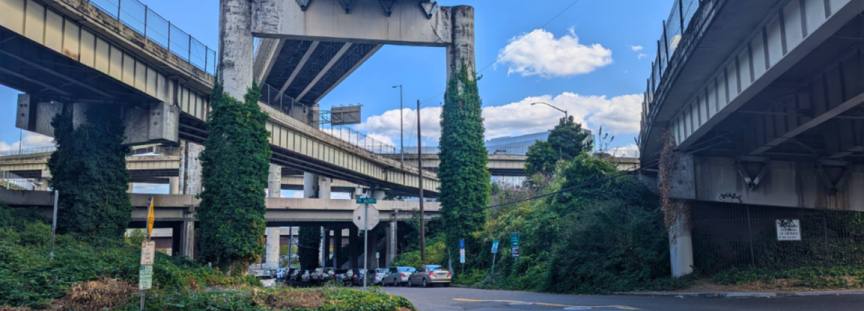
Not far from Portland State University, down a little road tucked under three highway overpasses, sits the International School of Portland (ISP)—a leafy four-acre campus serving nearly 400 students from preschool to fifth grade. Despite its proximity to popular pedestrian areas, including the Downtown Waterfront, the International School of Portland is nestled amongst a few private blocks and can be difficult to access by foot or by bike. Naturally, most students arrive by car, which creates the familiar traffic jam at pickup and dropoff times.

To provide more transportation options and give the students more access to the school's surrounding neighborhood, Portland State University students are working to improve walking and biking access to the campus. Championed by ISP’s volunteer Green Team, Facilities Manager Steven Borcherding, and Head of School ​​Bodo Heiliger, the project is now about one-third of the way through the Better Block PSU Project Pathway. Progress so far looks promising: PSU students in the 2024 Spring term spent time engaging with ISP’s school community and investigating the features of the neighborhood. This fall, PSU students in the Active Transportation Planning and Design Studio course (for which enrollment is open now) will delve further into the nuts and bolts of potential designs.

By the time the project crosses the finish line, the goal is to have a complete engineering plan for viable and affordable biking and walking facilities. Having an existing plan should make it much easier for the school to work with the city to implement the changes.

GOALS FOR THE INTERNATIONAL SCHOOL OF PORTLAND

The focus of the project is a small stretch of South Sheridan Street, under the Interstate 5 on-ramp and Interstate 405. The highway overpasses create a unique access obstacle, partly because of the lack of sidewalks on a road under multiple overpasses, but also because cars exiting the highway are entering the small road at close to highway speeds. There is also no accessibility for individuals in wheelchairs or with any mobility challenges.

The area is frequented by people who park there and walk to the South Waterfront along South Moody Avenue, where they can find multiple transit and micromobility options by the car-free Tilikum Bridge Crossing. Some of them are students and staff of downtown employers like nearby Oregon Health and Science University (OHSU). Connecting this stretch of Sheridan to the International School of Portland would also improve general access to the facilities on South Moody, and greater connectivity between the different parts of downtown.

"Ultimately, we see this as a great opportunity to beautify and create a safe access route for our entire neighborhood," said Heiliger. Based on a recommendation from a parent, he and Facilities Manager Borcherding are the ones who reached out to TREC with their project proposal for the Better Block PSU program.

Why turn to PSU students? 

There are many reasons. There is no cost to work with PSU transportation planning and engineering students in Better Block PSU, and the work the students produce can help community members navigate permitting processes and propose informed solutions to be implemented. Additionally, working with the students and engaging with neighborhood stakeholders is a form of community building, and in line with ISP's values of education to help students inquire, take action, and learn from real-world experiences.

WHAT WORK HAS BEEN DONE SO FAR?

Early in the Spring term of 2024, a group of students in the Bicycle and Pedestrian Planning course met with Heiliger and Borcherding to discuss the project. The team members were:

  • Evan Howington, a Masters in Urban and Regional Planning (MURP) student who also works as a graduate research assistant on other projects for TREC;
  • Shotaro Kato, an exchange student from Japan and an undergraduate in Urban and Public Affairs;
  • Steven Lowe, a senior-year undergraduate in Urban and Public Affairs;
  • Tristan Stretch, a graduate student in the Graduate Certificate for Transportation program.

After getting a sense of what the International School of Portland was hoping for, the group examined the history of the area to understand how it came to be. The road and the little patch of land under the overpasses are specifically mentioned in highway planning documents going back as far as the 1980s, but these spaces have not been meaningfully utilized in the years since. Team member Tristan Stretch felt good about helping to rectify a long-ignored situation that directly involves young schoolchildren.

"They're kids. They deserve safety and a nice enjoyable space to learn and grow," said Stretch.

The team came up with three main deliverables over the course of the term:

  • Existing Conditions Report – This report offers an overview of the site, including its planning history, land use, weather, and surrounding features. Students also conducted manual counts to identify how many bicycles, pedestrians and cars use the street during peak times of day.
  • Public participation plan – This report includes a project impact analysis and sample outreach materials, as well as a comprehensive public participation strategy.
  • Project Decisions and Performance Measures – This report defines the goals and objectives of the project, outlined below, along with design ideas. It also includes a decision matrix to evaluate the designs based on cost, time, accessibility, and how each design meets the needs of the school.

"Working with the PSU students and the university has been great; everyone is very flexible and curious to find solutions. This tiny little underpass by ISP creates a great deal of congestion, so this is a chance to bring our community together around a vision and expand safe access not only to our school but to the South Waterfront," Heiliger said.

If this project results in an easy walking connection from ISP to South Moody, that would open up brand-new transit options for parents who currently drive in from all over the metro area.

"We didn't record anyone that took public transit to school, only cyclists and pedestrians that were walking to school from a car, or from home. We made a map of the zip codes that people are driving from; some people come from as far as Vancouver, Washington. They drive that far just for the International School of Portland. Yet they are so close to so much transit," said Lowe.

WHAT'S NEXT?

There are three phases of the Better Block PSU project pathway each year.

Phase 1—Spring term 2024: Students in a Bicycle and Pedestrian Planning course work with the project champions to develop community engagement plans, activity and behavior monitoring, data collection plans, and performance measures.

Howington, Kato, Lowe and Stretch have completed this phase. This Fall, the South Sheridan Street project will move on to phase two.

Phase 2—Fall term 2024: Students in the Active Transportation Planning and Design Studio develop design alternatives and cost estimates.

This Fall, the Active Transportation Planning and Design Studio course may include some members of the group who worked on the project in the Spring term, continuing to develop what they started, while other students may be new to the project. 

Phase 3—Spring term 2025: A year after it first began, the project will be ready to move on to the final phase: the engineering capstone. In this phase, student(s) in the civil engineering program will develop an engineering plan that includes design alternatives, a traffic control plan, and other materials that can assist with the city permitting process.

"The Better Block PSU process is really cool because it starts broad and democratic, and then you get to the point where you can get the shovel out and actually do it," Howington said.

For the South Sheridan street redesign, it is anticipated that an engineering capstone student will take on this element of the project in early 2025.

MORE ABOUT BETTER BLOCK PSU 

Better Block PSU is a partnership between volunteer-led group Better Block PDX and Portland State University. Projects are submitted by community members, and can range from short-term demonstration projects—like the Montgomery Street Pop-Up Plaza on the PSU campus—to long-lasting changes like Better Naito, a student design which was first implemented in 2015 on a temporary basis and later made permanent

A more recent success story is the Steel Bridge Skatepark, which was designed by PSU students in 2023 and funded by the City of Portland in 2024. Construction of the park is ongoing. 

Read about other Better Block PSU projects here.

Portland State University's Transportation Research and Education Center (TREC) is home to the U.S. DOT funded National Institute for Transportation and Communities (NITC), the Initiative for Bicycle and Pedestrian Innovation (IBPI), PORTAL, BikePed Portal and other transportation grants and programs. We produce impactful research and tools for transportation decision makers, expand the diversity and capacity of the workforce, and engage students and professionals through education and participation in research. To get updates about what's going on at TREC, sign up for our monthly newsletter or follow us on social media.