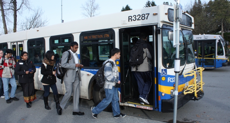
Traffic congestion on urban roadways can influence operating costs and cause travel delays.

Portland State University master’s students Nicholas Stoll and Travis Glick will present a paper introducing solutions for locating the sources of congestion at the 2016 annual meeting of the Transportation Research Board.

With their faculty advisor, Miguel Figliozzi, Stoll and Glick looked into using bus GPS data to identify congestion hot spots.

By using high-resolution GPS data to visualize trends in bus behavior and movement, the researchers were able to examine the sources of delay on urban arterials.

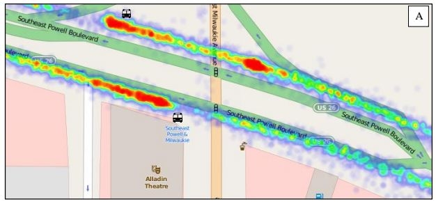
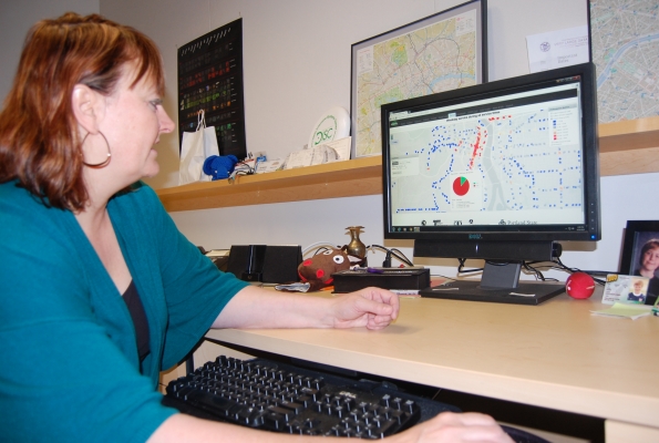
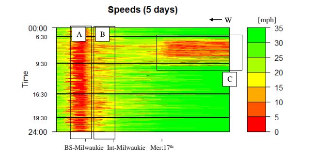
These visualizations, which can be in the form of heat maps or speed plots like the one shown here on the right (an application of numerical method applied to a 2,000 ft segment of SE Powell), can be used by transportation agencies to identify locations where improvements are needed. For example, adding a queue jump lane at a congested intersection can improve flow.

The researchers used fine-grained bus data provided by TriMet to create the visualizations. Buses have been used as probes to estimate travel times before, but with...

Read more

A new NITC project has developed a robust pedestrian demand estimation tool, the first of its kind in the country.

Using the tool, planners can predict pedestrian trips with spatial acuity.

The research was completed in partnership with Oregon Metro, and will allow Metro to allocate infrastructure based on pedestrian demand in the Portland, Oregon metropolitan area.

In a previous project completed last year as part of the same partnership, the lead investigator, Kelly Clifton, developed a way to collect data about the pedestrian environment on a small, neighborhood scale that made sense for walk trips. For more about how that works, click here to read our news coverage of that project. 

Following the initial project, the next step was to take that micro-level pedestrian data and use it to predict destination choice. For every walk trip generated by the model in the first project, this tool matches it to a likely destination based on traveler characteristics and environmental attributes.

Patrick Singleton, a graduate student researcher at Portland...

Read more

Seven dedicated students spent their summer days in TREC’s offices at PSU this year, working to transform the Bike-Ped Portal project from a dream into a reality.

TREC already houses Portal, a vast collection of Portland-area traffic and transit data, and NITC researchers saw a need for a database on the national scale for non-motorized transportation modes.

Research associate Krista Nordback launched the NITC pooled-fund project, Online Non-motorized Traffic Count Archive, with co-investigator Kristen Tufte in the spring of 2014. A year ago, Bike-Ped Portal was little more than an idea.

Now it contains roughly four million individual records of bicycle, pedestrian and even equestrian movements in five states.

High school interns Jolene Liu, Tomas Ramirez, Tara Sengupta, Gautum Singh, Kim Le, Max Fajardo and Kimberly Kuhn worked full time for weeks in order to convert piles of unsorted documentation into usable formats.

Nordback engaged the team of interns through Saturday Academy, a...

Read more

A NITC research project from Portland State University introduces a method of cleaning up land use data, for use in improved transportation models.

Transportation and land use are closely interdependent. Considerable work is underway, in Oregon and elsewhere, to develop models that integrate the two.

Planners creating these models often spend the bulk of their time preparing data on the various land uses. Many times the data, gathered from diverse sources, is incomplete and requires the planner to find missing information to fill in the gaps.

In fields outside of transportation, there have been considerable advances in techniques to do this. Data-mining and machine-learning techniques have been developed, for example, to systematically detect fraud in credit data, reconcile medical records and clean up information on the web.

In the transportation modeling community, by contrast, most efforts to tackle the problem are tied to a specific model system and a chosen study area. Few have produced reusable tools for processing land use data.

Liming Wang, lead investigator of the project Continuous Data Integration for Land Use and Transportation Planning and Modeling, offers such reusable...

Read more

Founded to collect the transportation data created by agencies across the region, Portal had done its job almost too well. The data archive, a program of TREC, had taken in more data than it could make available.

Portal started in 2004 with just one data source: Oregon freeway loop detectors. Over the years, it grew into a truly multimodal data archive, incorporating transit data, traffic signal data, bicycle and pedestrian counts – eight data sources spanning two states and multiple agencies.

Its budget didn’t grow proportionately, however, leaving Portal less able to make use of the data it collected. Portal’s $125,000 in regional transportation money just kept the system running, said Portal director Kristin Tufte. “It was enough money to keep the lights on,” she said.

Given Portal’s potential to help agencies improve operations and researchers to address systemwide issues, that wasn’t enough. The information had to be accessible to make a difference.

A boost in support for Portal is helping to make that possible. With a grant from the Institute for Sustainable Solutions at Portland State, TREC hired a Portal programmer this year to present the data visually.

Though key to Portal’s future...

Read more

Liming WangTransportation Cost Index: A Comprehensive Performance Measure for Transportation and Land Use Systems and its Application in OR, FL, and UT” is a Portland State University research project that will be presented at the 2015 annual meeting of the Transportation Research Board.

Portland State University researchers Liming Wang and Jenny Liu are developing a comprehensive performance measure that enables planners and the public to evaluate the performance of transportation and land use systems over time and across geographic areas.

Transportation engineers have a long history of using performance measures such as the Highway Performance Monitoring System (HPMS) to evaluate the operation of the transportation system. Traditionally, such measures heavily focus on the traffic condition, especially for drivers. 

Since the last decade, especially with the...

Read more

OTREC turned its education efforts on a decidedly younger crowd March 13: sixth graders. A class from Rochester, N.Y., visited Portland on a trip geared toward improving bicycling in their own community.

The students, from Genesee Community Charter School, visited the OTREC offices to learn about active transportation research methods. They took part in group exercises designed to get them thinking about the planning and engineering challenges of transportation systems set up to serve multiple transportation modes.

The highlight of the day came when the students took to Portland’s streets — OTREC’s living laboratory — to conduct research of their own. Armed with bicycle-counter tubes and infrared detectors, students counted cyclists and pedestrians passing on the Broadway cycle track on Portland State University’s campus.

Other students verified the technology with manual counters.

Students moved on to their next stop on a four-day tour of Portland with a better sense of what kind of data researchers collect and how they can use those data to inform policy. Given their experience — the students already have influenced their city on policy ranging from Erie Canal re-watering to an urban art corridor to skate parks — they stand a good chance of using Portland’s lessons to build a bike-friendly Rochester.

This fall, the Friday transportation seminar series at Portland State University has focused on data collection and how information is used to make transportation investments. The Oct. 26 seminar, with the University of Minnesota’s Greg Lindsey, covered tracking and modeling travel behavior.

Engineers and planners alike have relied on traffic counts for their traffic models, but data behind bike and pedestrian travel has been fuzzy. Now, researchers such as Lindsey are offering new methods for conducting bike and pedestrian counts on trails and multiuse paths.

With little guidance from the Federal Highway Administration, Lindsey said, most of the efforts in creating best practices have bubbled up from communities like the Twin Cities, chosen as Nonmotorized Transportation Pilot Cities. Lindsey and his researchers monitored six trails in Minneapolis, using inductive loops and infrared beams.

To address calibration problems and offer validity to their field numbers, Lindsey also sent students into the field to verify counts. The technology allowed for finer-grained detail, especially over a 24-hour period. OTREC Director Jennifer Dill noted, “Too much in the past we’ve lumped “bike and peds” together and your work and analysis is demonstrating that they truly are different modes, with different behaviors.”

Lindsey stressed the importance of conducting this type of research, and measuring our “bicycle miles traveled” and “pedestrian miles traveled” in...

Read more

If you weren’t one of the 10,000 people who attended the Transportation Research Board’s Annual Meeting in January, there are fifty students and twenty faculty for PSU, UO, OSU and OIT who can tell you what they learned there.  OTREC's bright yellow lanyards made our presence especially visible! PSU student Brian Davis blogged about his experience, OTREC’s Jon Makler was interviewed in a local newspaper, and the Oregon “delegation” at the conference was covered by both local and national blogs. Team OTREC filed some daily debriefs, highlighting presentations on topics such as federal stimulus investments in Los Angeles and Vermont’s efforts to address their transportation workforce crisis with returning military veterans (as well as the...

Read more

Watch video

View slides

SFpark was a federally-funded pilot program of a new approach to managing parking in San Francisco. It utilized real time data to identify parking availability, and demand-responsive parking pricing to help make parking easier to find. Parking management is an invaluable transportation demand management tool and the SFpark pilot demonstrated how data can help cities make smarter decisions. Come hear about the pilot evaluation results from a former SFpark staffer and PSU alum.

Kathryn Doherty-Chapman is a transportation planner focused on helping people access safe and healthy transportation options. She... Read more

Pages